
 French
 Deutsch
File:Territorial-acquisition-uscensus-bureau.jpg
Size of this preview: 756 × 599 pixels. Other resolutions: 303 × 240 pixels | 606 × 480 pixels | 969 × 768 pixels | 1,280 × 1,015 pixels | 1,409 × 1,117 pixels.
Original file (1,409 × 1,117 pixels, file size: 333 KB, MIME type: image/jpeg)
| This is a file from the Wikimedia Commons. Information from its description page there is shown below. Commons is a freely licensed media file repository. You can help. |
 | This map image could be re-created using vector graphics as an SVG file. This has several advantages; see Commons:Media for cleanup for more information. If an SVG form of this image is available, please upload it and afterwards replace this template with {{vector version available|new image name}}. It is recommended to name the SVG file “Territorial-acquisition-uscensus-bureau.svg”—then the template Vector version available (or Vva) does not need the new image name parameter. |


Summary
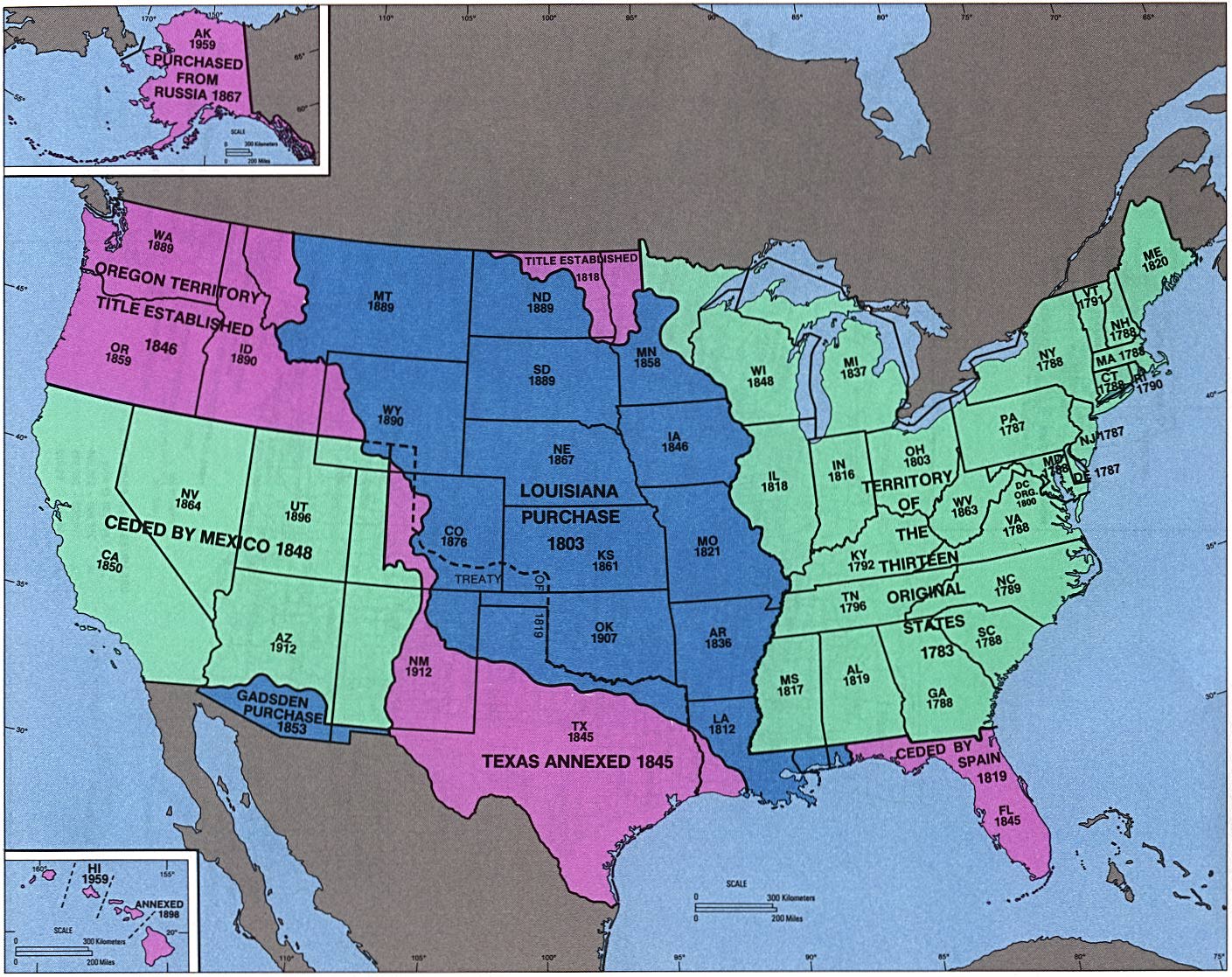
| Description | English: perry-castenada: Admission of States and Territorial Acquisition U.S. Bureau of the Census (341K) http://www.lib.utexas.edu/maps/histus.html |
| Source | US gov |
| Author | US gov |
Licensing
This image or file is a work of a United States Census Bureau employee, taken or made as part of that person's official duties. As a work of the U.S. federal government, the image is in the public domain.
|  |
Original upload log
The original description page was here. All following user names refer to en.wikipedia.
- 2004-09-30 02:05 Jengod 1409×1117×8 (341419 bytes) perry-castenada: Admission of States and Territorial Acquistion U.S. Bureau of the Census (341K) http://www.lib.utexas.edu/maps/histus.html
File history
Click on a date/time to view the file as it appeared at that time.
| Date/Time | Thumbnail | Dimensions | User | Comment | |
|---|---|---|---|---|---|
| current | 05:43, 18 April 2008 | | 1,409 × 1,117 (333 KB) | Urdangaray | {{Information |Description={{en|perry-castenada: Admission of States and Territorial Acquisition U.S. Bureau of the Census (341K) http://www.lib.utexas.edu/maps/histus.html en:Category:Historical maps of the United States}} |Source=Transferred fro |
File usage
The following pages on the English Wikipedia use this file (pages on other projects are not listed):
Global file usage
The following other wikis use this file:
- Usage on ar.wikipedia.org
- Usage on bn.wikipedia.org
- Usage on da.wikipedia.org
- Usage on de.wikipedia.org
- Usage on en.wikivoyage.org
- Usage on es.wikipedia.org
- Usage on eu.wikipedia.org
- Usage on fa.wikipedia.org
- Usage on it.wikipedia.org
- Usage on ms.wikipedia.org
- Usage on pt.wikipedia.org
- Usage on ro.wikipedia.org
- Usage on sr.wikipedia.org
- Usage on sv.wikipedia.org
- Usage on vi.wikipedia.org
- Usage on zh.wikipedia.org