
 French
 Deutsch
File:Topographic-Relief-perspective-sample.jpg
No higher resolution available.
Topographic-Relief-perspective-sample.jpg (796 × 468 pixels, file size: 97 KB, MIME type: image/jpeg)
| This is a file from the Wikimedia Commons. Information from its description page there is shown below. Commons is a freely licensed media file repository. You can help. |
Summary
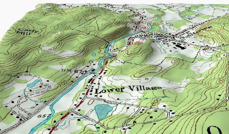
| Description | English: A perspective shaded-relief view of part of a topographic map sample. This perspective view illustrates how the contour lines on a Topographic map describe terrain by following the shape of the land at a constant elevation. Note: The vertical relief in this view has been exaggerated. |
| Date | 11 August 2004 (original upload date) |
| Source | Transferred from en.wikipedia to Commons. Derived from from USGS data files o44072d6.tif and 1631103.dem.sdts.tar.gz. |
| Author | Kbh3rd at English Wikipedia |
Licensing
Kbh3rd, the copyright holder of this work, hereby publishes it under the following licenses:
This file is licensed under the Creative Commons Attribution-Share Alike 2.0 Generic license.
Attribution: Kbh3rd
- You are free:
- to share – to copy, distribute and transmit the work
- to remix – to adapt the work
- Under the following conditions:
- attribution – You must give appropriate credit, provide a link to the license, and indicate if changes were made. You may do so in any reasonable manner, but not in any way that suggests the licensor endorses you or your use.
- share alike – If you remix, transform, or build upon the material, you must distribute your contributions under the same or compatible license as the original.
| This file is licensed under the Creative Commons Attribution-Share Alike 3.0 Unported license. Subject to disclaimers. | ||
| Attribution: Kbh3rd | ||
| ||
| This licensing tag was added to this file as part of the GFDL licensing update. |
 | Permission is granted to copy, distribute and/or modify this document under the terms of the GNU Free Documentation License, Version 1.2 or any later version published by the Free Software Foundation; with no Invariant Sections, no Front-Cover Texts, and no Back-Cover Texts. A copy of the license is included in the section entitled GNU Free Documentation License. Subject to disclaimers. |
You may select the license of your choice.
Original upload log
The original description page was here. All following user names refer to en.wikipedia.
- 2004-08-11 04:23 Kbh3rd 796×468× (99279 bytes) Shaded relief perspective view of topographic map sample
File history
Click on a date/time to view the file as it appeared at that time.
| Date/Time | Thumbnail | Dimensions | User | Comment | |
|---|---|---|---|---|---|
| current | 19:53, 3 February 2011 | | 796 × 468 (97 KB) | File Upload Bot (Magnus Manske) | {{BotMoveToCommons|en.wikipedia|year={{subst:CURRENTYEAR}}|month={{subst:CURRENTMONTHNAME}}|day={{subst:CURRENTDAY}}}} {{Information |Description={{en|'''Description''': A perspective shaded-relief view of part of a [[:en:Media:Topographic_map_example.pn |
File usage
The following pages on the English Wikipedia use this file (pages on other projects are not listed):
Global file usage
The following other wikis use this file:
- Usage on bn.wikipedia.org
- Usage on fa.wikipedia.org
- Usage on fo.wikipedia.org
- Usage on fr.wikipedia.org
- Usage on ja.wikipedia.org
- Usage on ml.wikipedia.org
- Usage on pt.wikipedia.org
- Usage on vi.wikipedia.org