
 French
 Deutsch
File:Torberry Hill map.gif

Size of this preview: 749 × 600 pixels. Other resolutions: 300 × 240 pixels | 600 × 480 pixels | 959 × 768 pixels | 1,094 × 876 pixels.
Original file (1,094 × 876 pixels, file size: 51 KB, MIME type: image/gif)
| This is a file from the Wikimedia Commons. Information from its description page there is shown below. Commons is a freely licensed media file repository. You can help. |
Summary
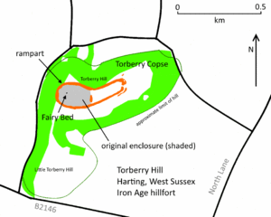
| Description | English: Map of Torberry Hill, near South Harting, West Sussex, England. Site of an Iron Age hillfort and a mill mound known as the Fairy Bed. Español: Mapa del cerro Torberry Hill, cerca de South Harting en el condado de West Sussex, Inglaterra. El cerro es el sitio de un fuerte de la edad de hierro, y de un montículo de un molino, que se llama "Fairy Bed" ("cama de hadas").
|
| Date | |
| Source | Own work |
| Author | Simon Burchell |
| Camera location | | View this and other nearby images on: OpenStreetMap |
|---|
Licensing
I, the copyright holder of this work, hereby publish it under the following license:
This file is licensed under the Creative Commons Attribution-Share Alike 4.0 International license.
- You are free:
- to share – to copy, distribute and transmit the work
- to remix – to adapt the work
- Under the following conditions:
- attribution – You must give appropriate credit, provide a link to the license, and indicate if changes were made. You may do so in any reasonable manner, but not in any way that suggests the licensor endorses you or your use.
- share alike – If you remix, transform, or build upon the material, you must distribute your contributions under the same or compatible license as the original.
File history
Click on a date/time to view the file as it appeared at that time.
| Date/Time | Thumbnail | Dimensions | User | Comment | |
|---|---|---|---|---|---|
| current | 18:09, 19 July 2014 | | 1,094 × 876 (51 KB) | Simon Burchell | Names of Torberry Hill and Little Torberry Hill |
| 17:22, 19 July 2014 |  | 1,094 × 876 (50 KB) | Simon Burchell | User created page with UploadWizard |
File usage
The following pages on the English Wikipedia use this file (pages on other projects are not listed):