
 French
 Deutsch
Heemstede
Heemstede | |
|---|---|
 | |
 Flag  Coat of arms | |
.svg) Location in North Holland | |
| Coordinates: 52°21′N 4°37′E / 52.350°N 4.617°E | |
| Country | Netherlands |
| Province | North Holland |
| Government | |
| • Body | Municipal council |
| • Mayor | Astrid Nienhuis (VVD) |
| Area | |
| • Total | 9.64 km2 (3.72 sq mi) |
| • Land | 9.18 km2 (3.54 sq mi) |
| • Water | 0.46 km2 (0.18 sq mi) |
| Elevation | 1 m (3 ft) |
| Population (January 2021)[4] | |
| • Total | 27,545 |
| • Density | 3,001/km2 (7,770/sq mi) |
| Demonym(s) | Heemstedenaar, Heemsteder |
| Time zone | UTC+1 (CET) |
| • Summer (DST) | UTC+2 (CEST) |
| Postcode | 2100–2106 |
| Area code | 023 |
| Website | www |
 | |
Heemstede (Dutch pronunciation: [ˈɦeːmsteːdə] ⓘ) is a town and a municipality in the Netherlands, in the province of North Holland. It is the fourth richest municipality of the Netherlands.[citation needed]
History[edit]
Heemstede formed around the Castle Heemstede that was built overlooking the Spaarne River around 1286. Before 1296, Floris V, Count of Holland, granted Heemstede as a fiefdom to Reinier of Holy. During the 14th century, a village formed near the castle, which was destroyed and rebuilt several times in this period. A resident of this castle was Adriaan Pauw, who bought it in 1620. In 1653, Bennebroek split off from Heemstede, becoming a separate fiefdom.
Growth was slow, and in 1787 Heemstede counted 196 families. Even at that early date Heemstede had already gained the reputation it has today, of being primarily a "bedroom community" for the cities of Haarlem and Amsterdam. Wealthy city families left the cities in the summer, escaping "canal fever" which caused illness from the putrid canals. As a result, many estates were built in the 17th and 18th centuries, some of which (partially) remain until today such as Oud-Berkenroede, Berkenrode, Ipenrode, Huis te Manpad, Hartekamp, Bosbeek, Meer en Bosch, Meer en Berg, and Gliphoeve.
In 1857, the municipality Berkenrode was merged with Heemstede. In 1927, the northern portion of Heemstede, including a large part of the Haarlem Forest, was in turn added to the city of Haarlem.
Monuments and parks[edit]
- Groenendaal park: Designed by John Hope, it was formed by merging several country estates into one.
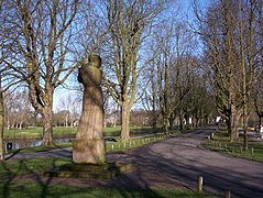
- Vrijheidsbeeld (Freedom Statue), statue by Mari Andriessen to celebrate freedom and commemorate Heemstede victims of the Dutch Revolt. Located on the Vrijheidsdreef in Groenendaal park.
- Slot Heemstede: The site of the Heemstede castle.
- Hartekamp: Heemstede summer home of George Clifford, who hired Linnaeus to write his 'Hortus Cliffortianus', a detailed catalogue of the plant specimens in the herbarium and gardens of Hartecamp. George Clifford's house is closed to the public, but the surrounding gardens are used as a campus and are open to visitors.
- Linnaeusbos (Linnaeus Forest): Originally a part of Hartekamp that was planted by George Clifford and documented by Linnaeus. In 2007, Heemstede celebrated Linnaeus's 300th birthday.
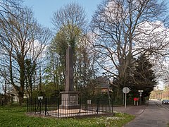
- De Naald: The 'needle' is a monument placed by D.J. van Lennep to honor Witte van Haemstede, the savior of Haarlem at a battle which on 26 April 1304 and to honor the wounded of another battle fought against the Spanish on 8 July 1573. Both battles supposedly took place right at the corner of David Jacob van Lennep's house Huis te Manpad, where the monument stands.
Transport[edit]
The town is served by Heemstede-Aerdenhout railway station, which lies on the Oude Lijn between Haarlem and Leiden.
Local government[edit]

The municipal council of Heemstede consists of 21 seats, which are divided as follows:
- Heemsteeds Burger Belang HBB - 5 seats
- VVD - 5 seats
- D66 - 4 seat
- GroenLinks - 3 seats
- CDA - 2 seats
- PvdA - 2 seats
Notable residents[edit]


- Adriaan Pauw (1585–1653) bought the town in 1621, Grand Pensionary of Holland 1631 to 1636
- Jan Hope (1737–1784) a Dutch banker, summered in his Groenendaal Park 1767 to 1784
- Christiaan van Pol (1752–1813) a flower painter and teacher
- Thomas Hope (1769–1830/1831) a Dutch and British merchant banker, author, philosopher and art collector [5]
- Ivan Smirnov (1895–1956) a Russian WWI flying ace and naturalized Dutch aviator, lived in Heemstede 1936-1947
- Johan Limpers (1915–1944) Dutch sculptor and WWII resistance fighter
- Jan Knappert (1927–2005) an Esperantist and expert on the Swahili language
- Pieter Kooijmans (1933–2013) Dutch politician, jurist and diplomat
- Jan Gmelich Meijling (1936–2012) a Dutch politician and naval officer
- Els Moor (1937 – 9 March 2016) was a Dutch-born Surinamese educator, editor and book publisher[6]
- Astrid Schulz (born 1939) a Dutch model and actress, Playboy Playmate of the Month in September 1964
- Gijs Kuenen (born 1940) a Dutch microbiologist and academic
- Mieke Bal (born 1946) a Dutch cultural theorist, video artist and academic
- Joost Swarte (born 1947) a Dutch cartoonist and graphic designer
- Dick Maas (born 1951) a Dutch film director, screenwriter and film producer[7]
- Floortje Dessing (born 1970) a Dutch radio and TV presenter, producer and travel writer[8]
- Thierry Baudet (born 1983) Dutch politician and leader of the Forum for Democracy
- Julian Ras - Dutch Wiki (born 2001) a Dutch actor[9]

Sport[edit]
- Joop van Dort (1889–1967) a footballer, team bronze medallist at the 1920 Summer Olympics
- Roepie Kruize (1925-1992) field hockey player and coach, team bronze medallist at the 1948 Summer Olympics and team silver medallist at the 1952 Summer Olympics
- Johan Neeskens (born 1951) a Dutch former footballer with 480 club caps and manager
- Annemieke Fokke (born 1967) a Dutch field hockey player, team bronze medallist at the 1988 Summer Olympics
- Jeroen Bleekemolen (born 1981) a Dutch professional racing driver
- Frank Korpershoek (born 1984) a Dutch professional footballer, 351 caps with SC Telstar
- Vincent Regeling (born 1997) a Dutch professional footballer
Image gallery[edit]
-
 Church: Onze Lieve Vrouw Hemelvaartskerk
 -
 Windmill, Groenendaal landmark
 -
 Vrijheidsbeeld by Andriessen
 -
 Oude Slot, site of the former Castle of Heemstede
 -
 Hartekamp or Hartecamp, Heemstede/Bennebroek
 -
 Heemstede, panoramio
 -
 Countryhouse: Huys te Manpad
 -
 Watertower
 -
 Memorial near Herenweg-Manpadslaan


.jpg)


References[edit]
- ^ "Samenstelling & portefeuilles" [Members and tasks] (in Dutch). Gemeente Heemstede. Retrieved 5 March 2014.
- ^ "Kerncijfers wijken en buurten 2020" [Key figures for neighbourhoods 2020]. StatLine (in Dutch). CBS. 24 July 2020. Retrieved 19 September 2020.
- ^ "Postcodetool for 2101HA". Actueel Hoogtebestand Nederland (in Dutch). Het Waterschapshuis. Archived from the original on 21 September 2013. Retrieved 5 March 2014.
- ^ "Bevolkingsontwikkeling; regio per maand" [Population growth; regions per month]. CBS Statline (in Dutch). CBS. 1 January 2021. Retrieved 2 January 2022.
- ^ . Encyclopædia Britannica. Vol. 13 (11th ed.). 1911.
- ^ "Moor, Elisabeth Henriette Pauline (1937-2016)". Digital Women Lexicon of the Huygens Institute (in Dutch). Retrieved 24 March 2021.
- ^ IMDb Database retrieved 03 February 2020
- ^ IMDb Database retrieved 03 February 2020
- ^ IMDb Database retrieved 03 February 2020
External links[edit]
 Media related to Heemstede, North Holland at Wikimedia Commons
- Official website
Places adjacent to Heemstede | ||||||||||||||||
|---|---|---|---|---|---|---|---|---|---|---|---|---|---|---|---|---|
| ||||||||||||||||

| National | |
|---|---|
| Geographic | |