
 French
 Deutsch
Iron Mountain (Madera County, California)
| Iron Mountain | |
|---|---|
 North aspect | |
| Highest point | |
| Elevation | 11,149 ft (3,398 m)[1][2] |
| Prominence | 748 ft (228 m)[3] |
| Parent peak | Starr Minaret (11,502 ft)[4] |
| Isolation | 2.79 mi (4.49 km)[4] |
| Listing | Sierra Peaks Section |
| Coordinates | 37°36′41″N 119°09′53″W / 37.6114227°N 119.1647610°W[5] |
| Naming | |
| Etymology | Iron ore |
| Geography | |
 Iron Mountain Location in California  Iron Mountain Iron Mountain (the United States) | |
| Location | Madera County, California, U.S. |
| Parent range | Sierra Nevada Ritter Range[3] |
| Topo map | USGS Cattle Mountain |
| Climbing | |
| Easiest route | class 2[4] South slope[1] |
Iron Mountain is an 11,149-foot-elevation (3,398 meter) summit located in the Sierra Nevada mountain range in Madera County of northern California, United States.[5] It is situated in the Ansel Adams Wilderness, on the boundary shared by Inyo National Forest with Sierra National Forest. It is set at the south end of the Ritter Range, approximately 10 miles (16 km) west of the community of Mammoth Lakes. Devils Postpile National Monument is 4.5 miles to the east and the Minarets are three miles to the north. Precipitation runoff from the west side of this mountain drains to North Fork San Joaquin River, and from the east slope to the Middle Fork San Joaquin. Topographic relief is significant as the east aspect rises over 2,000 feet (610 meters) above Anona Lake in approximately one mile. There are climbing routes to the summit via the south slope and east face,[6] and inclusion on the Sierra Peaks Section peakbagging list generates climbing interest.
Etymology[edit]
The mountain's name is attributable to iron ore found on the west shoulder of the peak.[7] The toponym was likely applied by the Wheeler Survey,[2] and has been officially adopted by the U.S. Board on Geographic Names.[5]
Climate[edit]
According to the Köppen climate classification system, Iron Mountain is located in an alpine climate zone.[8] Most weather fronts originate in the Pacific Ocean, and travel east toward the Sierra Nevada mountains. As fronts approach, they are forced upward by the peaks (orographic lift), causing them to drop their moisture in the form of rain or snowfall onto the range.
See also[edit]
Gallery[edit]
-
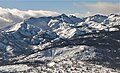 Iron Mountain's east aspect, seen from Mammoth Mountain.
 -
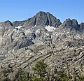
 Ritter Range seen from Mammoth Mountain. Iron Mountain to left.
 -
 West aspect
 -


References[edit]
- ^ a b R. J. Secor, The High Sierra Peaks, Passes, Trails, 2009, Third Edition, Mountaineers Books, ISBN 9781594857386, p. 376
- ^ a b Peter Browning, Place Names of the Sierra Nevada: From Abbot to Zumwalt, Wilderness Press, 1986, ISBN 9780899970479, page 107.
- ^ a b "Iron Mountain, California". Peakbagger.com. Retrieved 2022-05-23.
- ^ a b c "Iron Mountain - 11,148' CA". listsofjohn.com. Retrieved 2022-05-23.
- ^ a b c "Iron Mountain". Geographic Names Information System. United States Geological Survey, United States Department of the Interior. Retrieved 2022-05-23.
- ^ Walter A. Starr and Louis A. Elliott, A Climber’s Guide to the High Sierra (1954)
- ^ C. L. Severy (1946), Exploration of the Minarets Iron Deposit, Madera County, Calif, U.S. Department of the Interior, Bureau of Mines, p. 4.
- ^ "Climate of the Sierra Nevada". Encyclopædia Britannica.
External links[edit]
- NGS Data Sheet: Iron Mountain
- Aerial video of Iron Mountain and Iron Lake: Gettyimages.com