
 French
 Deutsch
Iturup
| Disputed island Native name: Ainu: エツ゚ヲロㇷ゚シㇼ | |
|---|---|
 Topographic map | |
 | |
 Iturup  Iturup | |
| Other names | Russian: Итуру́п; Japanese: 択捉島 |
| Geography | |
| Location | Sea of Okhotsk |
| Coordinates | 45°02′N 147°37′E / 45.033°N 147.617°E |
| Archipelago | Kuril Islands |
| Area | 3,139 km2 (1,212 sq mi) |
| Length | 200 km (120 mi) |
| Width | 27 km (16.8 mi) |
| Highest elevation | 1,634 m (5361 ft) |
| Highest point | Stokap |
| Administration | |
| Federal subject | Sakhalin Oblast |
| District | Kurilsky |
| Claimed by | |
| Prefecture | Hokkaido |
| Subprefecture | Nemuro |
| Demographics | |
| Population | 7,500 (2003) |
 | |
Iturup (Russian: Итуру́п), also historically known by other names, is an island in the Kuril Archipelago separating the Sea of Okhotsk from the North Pacific Ocean. The town of Kurilsk, administrative center of Kurilsky District, is located roughly midway along its western shore. Iturup is the largest and northernmost of the southern Kurils, ownership of which is disputed by Japan and Russia. It is located between Kunashiri 19 km (12 mi) to its southwest and Urup 37 km (23 mi) to its northeast. The Vries Strait between Iturup and Urup forms the Miyabe Line dividing the predominant plants of the Kurils.
The native inhabitants of the islands since at least the 14th century were the Ainu. Various European explorers passed the area over the years but settlement varied between Russian and Japanese. The island was formally claimed as Japanese territory in 1855. Near the end of the Second World War in 1945, the Soviet Union occupied the southern Kurils and forcibly removed its Japanese residents. Japan continues to claim the islands and considers the northern edge of the island to be its own northernmost point.
Names[edit]
The modern English name Iturup and earlier Yetorup are romanizations of the Russian name Ostrov Iturúp (Остров Итуру́п, "Iturup Island").[1] It was previously known in English as Etrof[2] from the Japanese name Etorofu-tō (択捉島, "Iturup Island").[3] Both the Russian and Japanese names come from the native Ainu Etuworop-sir (エツ゚ヲロㇷ゚シㇼ), meaning "island with many capes".
Geography[edit]
Iturup consists of volcanic massifs and mountain ridges. A series of a dozen calc-alkaline volcanoes running NE to SW form the backbone of the island, the highest being Stokap (1,634 m) in the central part of Iturup. The shores of the island are high and abrupt. The vegetation mostly consists of spruce, larch, pine, fir, and mixed deciduous forests with alder, lianas and Kuril bamboo underbrush. The mountains are covered with birch and Siberian Dwarf Pine scrub, herbaceous flowers (including Fragaria iturupensis, the Iturup strawberry) or bare rocks.
The island also contains some high waterfalls, such as the Ilya Muromets.
Rheniite, a rhenium sulfide mineral (ReS2), was discovered in active hot fumaroles on Kudriavy volcano and first described in 2004. In the field it was originally mistaken for molybdenite.[4]
Vetrovoy isthmus[edit]
The development of the Kuril Island arc was significantly influenced by extensive caldera-forming volcanic eruptions during the Late Neo-Pleistocene-Holocene, which introduced large amounts of pumice-pyroclastic material and tephra into the wave processing zone. On Iturup Island, the formation of four large collapse calderas during the Late Neo-Pleistocene-Holocene resulted in the release of about 450 km3 of predominantly dacite pyroclastics.[5]
The formation of the subaerial Vetrovoy isthmus is attributed to the accumulation of such material during powerful explosive caldera-forming eruptions in the shallow strait between neighbouring islands.[6] The present geomorphological appearance of the isthmus is a consequence of subsequent wave and aeolian pyroclastic processing, leading to the formation of marine and lagoon terraces.[7]
A study by Afanas'ev et al.[8] focuses on examining the existence of the strait separating the southern and northern parts of Iturup Island in the mid-late Holocene from the perspective of coastal geomorphology. Late Pleistocene explosive volcanism is considered to have been more intense and prolonged than Early Holocene events, leading to the formation of pumice deposits in the Prostor Gulf of Iturup Island. Radiocarbon dating of the peat bog underlying the pumice-pyroclastic cover in the Vetrovoy Isthmus suggests events around 38,000-39,000 years ago.[9]
The stratigraphy, genesis and chronology of the Holocene deposits on Iturup Island are poorly studied, relying primarily on C14 dates from Kasatka Bay and Olga Bay[14]. Three transgressive phases of sedimentation, comparable to the Atlantic, Subboreal and Sub-Atlantic periods, with a maximum sea level rise of up to 3.5 metres above the present level in the Atlantic, have been identified at the mouth of the Kurilka River.[10]
Fieldwork conducted in 2017-2018 on the Vetrovoy isthmus revealed volcanic-tectonic dislocations with a layer of beach material, suggesting the occurrence of at least two pyroclastic outbursts in the mid-Late Holocene. Georadar surveys complemented the manual drilling results, providing insights into the geological features of the isthmus.[11]
The deposits of the Vetrovoy Isthmus include volcanic-tectonic dislocations, pumice pyroclastics, aeolian-ash deposits and soil-tephra formations. The morphometric parameters of the basement terrace indicate an area elevation rate during the last phase of coastal marine accumulation that could reach 4 mm/year, slightly higher than the 3.5 m/year recorded during the last 6000 thousand years.[12]
In conclusion, several studies suggest that explosive volcanism in the middle Late Holocene significantly affected the morphotectonic plan of the Vetrovoy Isthmus area, possibly contributing to the obstruction of the strait. The rise of the terrace surface during the middle Holocene may be related to these volcanic events. The rate of uplift of the area during the last phase of coastal marine accumulation is thought to have been about 4 mm/year. However, there are currently no data on the age of the marine georadar facies identified as a result of research on the Vetrovoy isthmus.[13]
History[edit]
Prehistory[edit]
The native inhabitants of all the Kuril islands are the Ainu. They have lived there since at least the 14th century.
Edo period[edit]
.jpeg)
Europeans are first recorded visiting this part of the Kurils in 1643[14] when the Castricum under Maarten Gerritsz Vries was exploring Hokkaido and the surrounding area for the Dutch East India Company (VOC).[15] As with neighboring Urup, Iturup is sometimes said to have been the particular island intended in his account,[16] but in fact his description of an enormous continental Company Land (named after the VOC) and a large and prosperous Staten Island (named after the States General) bear no relation to anything in the area,[17] a fact established by Vitus Bering's lieutenant Martin Spanberg in a series of voyages in 1738, 1739, and 1742.[18] The phantom Staten Island (Staten Eyland; French: Isle des États) still continued to appear on European maps for decades afterward, however,[18] and is now sometimes specifically conflated with Iturup despite its placement on most maps more closely matching Kunashiri.
The Japanese are first recorded reaching Iturup in 1661, when Shichirobei and his company drifted there by accident. Following Bering and Spanberg's voyages under the Russian flag, a settlement was established in the late 18th century, prompting the Japanese to establish a garrison around 1800 at the site of present-day Kurilsk. Japanese rule over Iturup was formally recognized in the 1855 Treaty of Shimoda.
Showa period[edit]

On 26 November 1941, a Japanese carrier fleet left Hitokappu Bay (now called Kasatka Bay[19]), on the eastern shore of Iturup, and sailed for an attack on the American base of Pearl Harbor.
Shana Village was located on Iturup (Etorofu) in the Showa era, before 1945. It was the administrative capital of the Kuril islands. There was a village hospital, an Etorofu Fisheries factory, a radio tower of the post office with a radio receiving antenna. The receiver was battery-powered.[20]
Post-World War II[edit]
In 1945, according to decisions of the Yalta Conference, it was occupied by the Soviet Union after Japan's defeat in World War II. The Japanese inhabitants were expelled to mainland Japan.[21] In 1956 the two countries agreed to restore diplomatic relations, but a peace treaty, as of 2023[update], has not been concluded due to the disputed status of Iturup and some other nearby islands.
A Soviet Anti-Air Defense (PVO) airfield, Burevestnik (English: storm-petrel), is located on the island and was until 1993 home for a number of Mikoyan-Gurevich MiG-23 fighter jets.[22] In 1968, Seaboard World Airlines Flight 253A was intercepted over the Kurils and forced to land at Burevestnik with 214 American troops bound for Vietnam. An older airfield, Vetrovoe, exists on the eastern part of the island and may have been used primarily by Japanese forces during World War II.
Contemporary period[edit]
A new international airport, Iturup Airport, was opened in 2014, 7 kilometres (4+1⁄2 miles) east of Kurilsk. It was the first airport built from scratch in Russia's post-Soviet history. It has a 2.3-kilometre-long (7,500 ft), 42-metre-wide (138 ft) runway and can receive Antonov An-74-200 aircraft. It also has a military use. The Burevestnik military airfield 60 km (37 mi) to the south, in the past received civilian aircraft as well, but was often closed because of fog. Burevestnik is now a reserve airfield for the new airport.[23] On February 2, 2018, PBS NewsHour reported that Russia announced it is sending fighter planes to Iturup.[24] Su-35 aircraft landed on a reserve airfield on the island in March 2018[25][26] and Su-35s were then deployed to Iturup airport on a trial basis in August 2018.[27]
Administratively the island belongs to the Sakhalin Oblast of the Russian Federation. Japan claims Iturup as part of Nemuro Subprefecture.
Gallery[edit]
-
 Volcanoes of Iturup
 -
 Kurilsk, 1981
 -
 Iturup, 1981
 -
 Trees showing effect of prevailing wind, 1981
 -
 Shana Village in Etorofu (Shōwa period). There is a village hospital in the front, a factory in the left back with a fishery and a central radio tower (before 1945).
 -
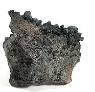 Rheniite crystals on a base of hardened lava, from Kudriavy Volcano


See also[edit]
References[edit]
- ^ "Ostrov Iturup: Russia". Geographical Names. Retrieved 2014-02-24.
- ^ Contemporary Japan, Volume 24. Foreign Affairs Association of Japan. 1956. p. 520.
- ^ "Etorofu-tō: Russia". Geographical Names. Retrieved 2014-02-24.
- ^ Korzhinsky, M.A.; Tkachenko, S. I.; Shmulovich, K. I.; Taran, Y. A.; Steinberg, G. S. (5 May 2004). "Discovery of a pure rhenium mineral at Kudriavy volcano". Nature. 369 (6475): 51–52. Bibcode:1994Natur.369...51K. doi:10.1038/369051a0. S2CID 4344624.
- ^ Melekestsev I V et al. 2005 The newest and modern volcanism in Russia (Moscow: Nauka) p. 604.
- ^ Korsunskaya G V 1958 The Kurile Island Arc (Moscow: Geographgis) p 224.
- ^ Afanas'ev V V, Dunaev N N, Gorbunov A O and Uba A V 2018 Manifestation of Calderaforming volcanism in the formation of the sea coast (on the example of Iturup island of the Large Kuril Arc) J. Processes in geoenvironments 3. 16 990-98.
- ^ Afanas'ev, V. V., et al. "Vetrovoy isthmus of Iturup island-holocene strait". IOP Conference Series: Earth and Environmental Sciences. Vol. 324. No. 1. IOP Publishing, 2019.
- ^ Bazanova L I, Melekestsev I V, Ponomareva V V, Dirksen O V, Dirksen V G et al 2016 Late Pleistocene and Holocene volcanic catastrophes in Kamchatka and in the Kuril Islands. Part 1. Types and classes of catastrophic eruptions as major components of volcanic catastrophism J. of volcanology and seismology 3. 151-69.
- ^ Korotky A M et al. 2000 Sedimentation and paleolandscapes of the late Pleistocene-Holocene of the basin of the Kurilka river (Iturup island, Kuril Islands) J. Pacific Geology 5. 19 61-77.
- ^ Razzhigaeva N G and Ganzey L A 2006 Depositional environments of the island territories in the Pleistocene-Holocene (Vladivostok: Dalnauka) р 365.
- ^ Bulgakov R F 1994 History of the southern islands of the Great Kuril Arc in the Pleistocene: autoref. Diss. of candidate of geogr. Sciences (Moscow: MSU) p 20.
- ^ Razzhigaeva N G and Ganzey L A 2006 Depositional environments of the island territories in the Pleistocene-Holocene (Vladivostok: Dalnauka) р 365.
- ^ "The 17th and 18th Centuries". Archived from the original on 2008-03-25. Retrieved 2008-03-25.
- ^ De Saint-Martin et al. (1895), p. 444–445.
- ^ Heawood, Edward (1912). A history of geographical discovery in the seventeenth and eighteenth centuries. Cambridge: Cambridge University Press. pp. 87.
- ^ De Saint-Martin, Vivien; et al., eds. (1895), "Yèso", Nouveau Dictionnaire de Géographie Universelle (in French), vol. 7, Paris: Librairie Hachette & Co., p. 441–445.
- ^ a b Wroth, Lawrence C. (1944), "The Early Cartography of the Pacific", The Papers of the Bibliographical Society of America, vol. 38, Chicago: University of Chicago Press, pp. 87–231 & 233–268, JSTOR 24301919.
- ^ Внешняя политика Японии: сентябрь 1939 г.-декабрь 1941 г – 1959, page 246 (in Russian)
- ^ "Sana, the administrative capital - 行政の首都 紗那(しゃな)". Chishima People's Magazine Study Group (千島庶民誌研究会). 6 October 2016. Archived from the original on 10 November 2017. Retrieved 20 January 2020.
- ^ Takahara, "Nemuro raid survivor"
- ^ Austin, Greg; Muraviev, Alexey D. (2000). The Armed Forces of Russia in Asia. London: I.B.Tauris. p. 244. ISBN 9781860644856. Retrieved 16 June 2018.
- ^ "New airport on Kuril Iturup Island receives first flight". Russia Beyond. Interfax. 22 September 2014. Retrieved 16 June 2018.
- ^ "PBS NewsHour full episode February 2, 2018 (Time Index 8:37)". Retrieved 26 October 2014.
- ^ "Russian fighter jets land on disputed island". Xinhua News Agency. March 26, 2018. Archived from the original on August 5, 2018. Retrieved August 5, 2018.
- ^ Gady, Franz-Stefan (August 1, 2018). "Japan Asks Russia to Reduce Militarization of Disputed Kuril Islands". The Diplomat. Retrieved August 5, 2018.
- ^ "Report: Fighter jets deployed on Etorofu for trial". NHK. August 4, 2018. Retrieved August 5, 2018.
External links[edit]
- Takahara, Kanako (September 22, 2007). "Nemuro raid survivor longs for homeland" (Newspaper article). Japan Times. Retrieved 2008-02-01.
- Google Maps
- Ocean Dots.com at the Wayback Machine (archived December 23, 2010)
- Sakhalin Oblast
| International | |
|---|---|
| National | |