| Name | Address | Coordinates | Government recognition (CRHP №) |  | Image |
| Canadian Pacific Railway Station (VIA Rail), Former | 120 Canada Avenue
Duncan BC | 48°46′40″N 123°42′25″W / 48.7779°N 123.7070°W / 48.7779; -123.7070 (Canadian Pacific Railway Station (VIA Rail), Former) | Federal (15463) | | 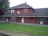 |
| 516 First Avenue Building | 516 First Avenue
Ladysmith BC | 48°59′37″N 123°49′04″W / 48.9935°N 123.8177°W / 48.9935; -123.8177 (516 First Avenue Building) | Ladysmith municipality (20308) | | 
Upload Photo |
| 530 First Avenue Building | 530 First Avenue
Ladysmith BC | 48°59′37″N 123°49′05″W / 48.9935°N 123.818°W / 48.9935; -123.818 (530 First Avenue Building) | Ladysmith municipality (16590) | | 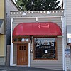 |
| Coburn-Verchere Residence | 641 Third Avenue
Ladysmith BC | 48°59′34″N 123°49′18″W / 48.9928°N 123.8218°W / 48.9928; -123.8218 (Coburn-Verchere Residence) | Ladysmith municipality (20328) | |
Upload Photo |
| Comox Logging and Railway Shops Building | 610 Oyster Bay Drive
Ladysmith BC | 48°59′43″N 123°48′57″W / 48.9954°N 123.8157°W / 48.9954; -123.8157 (Comox Logging and Railway Shops Building) | Ladysmith municipality (20271) | |
Upload Photo |
| Eagles Hall | 921 First Avenue
Ladysmith BC | 48°59′46″N 123°49′18″W / 48.9962°N 123.8217°W / 48.9962; -123.8217 (Eagles Hall) | Ladysmith municipality (20309) | |
Upload Photo |
| Island Hotel | 440 First Avenue
Ladysmith BC | 48°59′36″N 123°49′03″W / 48.9933°N 123.8174°W / 48.9933; -123.8174 (Island Hotel) | Ladysmith municipality (16588) | |
Upload Photo |
| Jessup's Drug Store | 18 High Street
Ladysmith BC | 48°59′39″N 123°49′04″W / 48.9943°N 123.8177°W / 48.9943; -123.8177 (Jessup's Drug Store) | Ladysmith municipality (20329) | |
Upload Photo |
| Johnson's Shoes | 526-528 First Avenue
Ladysmith BC | 48°59′37″N 123°49′04″W / 48.9936°N 123.8179°W / 48.9936; -123.8179 (Johnson's Shoes) | Ladysmith municipality (20332) | |
Upload Photo |
| Jones Hotel | 12 Gatacre Street
Ladysmith BC | 48°59′38″N 123°49′00″W / 48.9938°N 123.8166°W / 48.9938; -123.8166 (Jones Hotel) | Ladysmith municipality (20289) | |
Upload Photo |
| Ladysmith Agricultural Hall and Sports Field | 1110 First Avenue
Ladysmith BC | 48°59′50″N 123°49′25″W / 48.9973°N 123.8236°W / 48.9973; -123.8236 (Ladysmith Agricultural Hall and Sports Field) | Ladysmith municipality (18949) | |
Upload Photo |
| Ladysmith Railway Station | Esplanade Avenue
Ladysmith BC | 48°59′43″N 123°48′57″W / 48.9952°N 123.8158°W / 48.9952; -123.8158 (Ladysmith Railway Station) | Ladysmith municipality (20333) | | 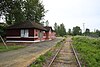 |
| Ladysmith Trading Company | 410 First Avenue
Ladysmith BC | 48°59′33″N 123°49′01″W / 48.9926°N 123.817°W / 48.9926; -123.817 (Ladysmith Trading Company) | Ladysmith municipality (16586) | | 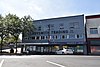 |
| Mainstreet Building | 512 First Avenue
Ladysmith BC | 48°59′36″N 123°49′05″W / 48.9932°N 123.818°W / 48.9932; -123.818 (Mainstreet Building) | Ladysmith municipality (16589) | | 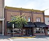 |
| Masonic Hall | 26 Gatacre Street
Ladysmith BC | 48°59′37″N 123°49′01″W / 48.9935°N 123.8170°W / 48.9935; -123.8170 (Masonic Hall) | Ladysmith municipality (20331) | |
Upload Photo |
| Music Hall | 18 Roberts Street
Ladysmith BC | 48°59′35″N 123°48′57″W / 48.9930°N 123.8158°W / 48.9930; -123.8158 (Music Hall) | Ladysmith municipality (20330) | |
Upload Photo |
| Nicholson Block | 436 First Avenue
Ladysmith BC | 48°59′35″N 123°49′05″W / 48.993°N 123.818°W / 48.993; -123.818 (Nicholson Block) | Ladysmith municipality (16587) | |  |
| Old Post Office | 340 Esplanade Avenue
Ladysmith BC | 48°59′36″N 123°48′53″W / 48.9933°N 123.8148°W / 48.9933; -123.8148 (Old Post Office) | Ladysmith municipality (20272) | |
Upload Photo |
| St. John the Evangelist Anglican Church | 314 Buller Street
Ladysmith BC | 48°59′34″N 123°49′20″W / 48.9927°N 123.8223°W / 48.9927; -123.8223 (St. John the Evangelist Anglican Church) | Ladysmith municipality (18948) | |
Upload Photo |
| Temperance Hotel | 32 High Street
Ladysmith BC | 48°59′39″N 123°49′05″W / 48.9941°N 123.8181°W / 48.9941; -123.8181 (Temperance Hotel) | Ladysmith municipality (20274) | |
Upload Photo |
| The Convent School | 210 Buller Street
Ladysmith BC | 48°59′37″N 123°49′15″W / 48.9937°N 123.8208°W / 48.9937; -123.8208 (The Convent School) | Ladysmith municipality (20288) | |
Upload Photo |
| Traveller's Hotel | 422 First Avenue
Ladysmith BC | 48°59′34″N 123°49′01″W / 48.9928°N 123.817°W / 48.9928; -123.817 (Traveller's Hotel) | Ladysmith municipality (6317) | |  |
| Kinsol Trestle | Cowichan Valley Trail
Shawnigan Lake BC | 48°40′08″N 123°41′38″W / 48.6688°N 123.694°W / 48.6688; -123.694 (Kinsol Trestle) | Shawnigan Lake municipality (18478) | |  |

 French
 Deutsch


