
 French
 Deutsch
McHenrys Peak
| McHenrys Peak | |
|---|---|
 East aspect | |
| Highest point | |
| Elevation | 13,327 ft (4,062 m)[1][2] |
| Prominence | 884 ft (269 m)[3] |
| Parent peak | Chiefs Head Peak (13,577 ft)[3][4] |
| Isolation | 1.23 mi (1.98 km)[3] |
| Coordinates | 40°15′47″N 105°39′27″W / 40.2629199°N 105.6573871°W[5] |
| Naming | |
| Etymology | Prof. Benjamin F. McHenry |
| Geography | |
 McHenrys Peak Location in Colorado  McHenrys Peak McHenrys Peak (the United States) | |
| Country | United States |
| State | Colorado |
| County | Grand County / Larimer County |
| Protected area | Rocky Mountain National Park |
| Parent range | Rocky Mountains Front Range |
| Topo map | USGS McHenrys Peak |
| Geology | |
| Age of rock | Precambrian[7] |
| Type of rock | Granite of Longs Peak batholith[6] |
| Climbing | |
| Easiest route | class 3 scrambling[3] |
McHenrys Peak is a 13,327-foot-elevation (4,062-meter) mountain summit on the boundary shared by Grand County and Larimer County in Colorado, United States.
Description[edit]
McHenrys Peak is set on the Continental Divide in the Front Range of the Rocky Mountains.[4] The mountain is situated within Rocky Mountain National Park. It is the fifth-highest peak in Larimer County.[8] Precipitation runoff from the mountain's east slope drains into Glacier Creek which is a tributary of the Big Thompson River, and the west slope drains to Grand Lake via North Inlet. Topographic relief is significant as the summit rises 1,850 feet (560 meters) above Lake Powell in 0.62 mile (1 km) and 2,725 feet (831 meters) above Black Lake in one mile (1.6 km).
Etymology[edit]
The mountain's toponym was officially adopted in 1911 by the United States Board on Geographic Names.[5] Abner Sprague named the peak after Professor Benjamin F. McHenry of Union Christian College, Merom.[9] McHenry spent three summers in this area during the 1890s. Abner Sprague had a homestead at Sprague Lake with a view of McHenry Peak, Otis Peak, and Hallett Peak.
Climate[edit]
According to the Köppen climate classification system, McHenrys Peak is located in an alpine subarctic climate zone with cold, snowy winters, and cool to warm summers.[10] Due to its altitude, it receives precipitation all year, as snow in winter and as thunderstorms in summer, with a dry period in late spring.
Gallery[edit]
-
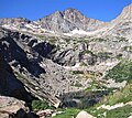 East face above Black Lake
 -
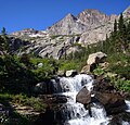 McHenrys with Ribbon Falls


See also[edit]
References[edit]
- ^ Robert M. Ormes (2000), Guide to the Colorado Mountains, Colorado Mountain Club Press, ISBN 9780967146607, p. 43.
- ^ "McHenrys Peak, Colorado". Peakbagger.com. Retrieved April 24, 2023.
- ^ a b c d "McHenrys Peak - 13,330' CO". listsofjohn.com. Retrieved April 24, 2023.
- ^ a b "McHenrys Peak, Peakvisor.com". Retrieved April 24, 2023.
- ^ a b "McHenrys Peak". Geographic Names Information System. United States Geological Survey, United States Department of the Interior. Retrieved April 24, 2023.
- ^ Geologic map of the Estes Park 30' x 60' quadrangle, north-central Colorado, W.A. Braddock, U.S. Geological Survey, 1984.
- ^ Lexicon of Geologic Names of the United States (including Alaska). Part 2 (1936), U.S. Government Printing Office, p. 2227.
- ^ Larimer County CO Peaks List, listsofjohn.com, Retrieved April 24, 2023.
- ^ Louisa Ward Arps, Elinor Eppich Kingery, (1994), High Country Names: Rocky Mountain National Park and Indian Peaks, Johnson Books, ISBN 9781555661335
- ^ Peel, M. C.; Finlayson, B. L.; McMahon, T. A. (2007). "Updated world map of the Köppen−Geiger climate classification". Hydrol. Earth Syst. Sci. 11. ISSN 1027-5606.
External links[edit]
- Weather forecast: McHenrys Peak
- Benjamin F. McHenry: photo
- Benjamin F. McHenry: photo
Places adjacent to McHenrys Peak | ||||||||||||||||
|---|---|---|---|---|---|---|---|---|---|---|---|---|---|---|---|---|
| ||||||||||||||||