Merrifield, Virginia
Merrifield, Virginia | |
|---|---|
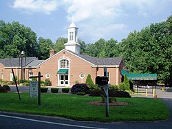
 A church in Merrifield | |
 Location of Merrifield in Fairfax County, Virginia | |
| Coordinates: 38°52′23″N 77°14′35″W / 38.87306°N 77.24306°W | |
| Country | United States |
| State | Virginia |
| County | Fairfax |
| Area | |
| • Total | 2.72 sq mi (7.05 km2) |
| • Land | 2.71 sq mi (7.03 km2) |
| • Water | 0.008 sq mi (0.02 km2) |
| Elevation | 361 ft (110 m) |
| Population (2020) | |
| • Total | 20,488 |
| • Density | 5,602/sq mi (2,163.0/km2) |
| Time zone | UTC−5 (Eastern (EST)) |
| • Summer (DST) | UTC−4 (EDT) |
| Area code | 703 |
| FIPS code | 51-51192[1] |
| GNIS feature ID | 1493280[2] |
Merrifield is a census-designated place (CDP) in Fairfax County, Virginia, United States. The population was 20,488 at the 2020 census.[3]
Geography[edit]

Merrifield is located in eastern Fairfax County at 38°52′23″N 77°14′35″W / 38.87306°N 77.24306°W (38.873144, −77.242994).[4] It is bounded by I-66 on the north, the Capital Beltway on the east, Arlington Boulevard (U.S. Route 50) on the south, and Nutley Street (Virginia State Highway 243) on the west. Neighboring communities are Oakton to the west, the town of Vienna to the north, Dunn Loring to the northeast, Idylwood and West Falls Church to the east, Annandale at the southeast corner of Merrifield, Woodburn and Mantua to the south, and the city of Fairfax to the southwest. Downtown Washington, D.C., is 13 miles (21 km) to the east.
According to the United States Census Bureau, the CDP has a total area of 2.7 square miles (7.0 km2), of which 0.01 square miles (0.02 km2), or 0.23%, is water.[5]
Demographics[edit]
2020 Census[edit]
As of the 2020 census (some information from the 2022 American Community Survey) there were 20,488 people, 9,616 housing units and 9,121 households residing in the CDP. The population density was 7,532.4 inhabitants per square mile (2,906.1/km2). The average housing unit density was 3,535.3 per square mile (1,364.0/km2). The racial makeup of the CDP was 42.85% White, 6.61% African American, 0.47% Native American, 31.26% Asian, 0.07% Pacific Islander, 7.17% from other races, and 11.56% from two or more races. Hispanic or Latino of any race was 15.10% of the population.[3]
Of the households, 44.6% were married couples, 25.3% were a male householder with family but no spouse, and 25.3% were a female householder with family but no spouse. The average family household had 2.87 people.[3]
The median age was 33.8, 17.2% of people were under the age of 18, and 7.5% were 65 years of age or older. Of the residents, 4.1% had Italian ancestry, 49.7% spoke a language other than English at home, and 43.3% were born outside the United States, 45.3% of whom were naturalized citizens.[3]
The median income for a household in the CDP was $134,022, and the median income for a family was $166,076. 4.1% of the population were military veterans, and 79.3% had a batchelor's degree or higher. In the CDP 6.4% of the population was below the poverty line, including 5.5% of those under age 18 and 11.1% of those age 65 or over, with 5.6% of the population without health insurance.[3]
2010 Census[edit]
The population was 15,212 at the 2010 census.[5]
2000 Census[edit]
As of the census[1] of 2000, there were 11,170 people, 4,396 households, and 2,725 families residing in the CDP. The population density was 4,107.2 inhabitants per square mile (1,585.8/km2). There were 4,534 housing units at an average density of 1,667.1 per square mile (643.7/km2). The racial makeup of the CDP was 54.67% White, 5.94% African American, 0.25% Native American, 29.94% Asian, 0.10% Pacific Islander, 5.00% from other races, and 4.11% from two or more races. Hispanic or Latino of any race were 12.91% of the population.
There were 4,396 households, out of which 28.1% had children under the age of 18 living with them, 48.7% were married couples living together, 8.8% had a female householder with no husband present, and 38.0% were non-families. 25.0% of all households were made up of individuals, and 3.5% had someone living alone who was 65 years of age or older. The average household size was 2.54 and the average family size was 3.06.
In the CDP, the population was spread out, with 19.4% under the age of 18, 10.3% from 18 to 24, 42.7% from 25 to 44, 21.4% from 45 to 64, and 6.2% who were 65 years of age or older. The median age was 33 years. For every 100 females, there were 102.4 males. For every 100 females age 18 and over, there were 103.3 males.
The median income for a household in the CDP was $70,363, and the median income for a family was $74,116. Males had a median income of $55,653 versus $43,095 for females. The per capita income for the CDP was $32,819. About 5.3% of families and 7.4% of the population were below the poverty line, including 11.5% of those under age 18 and 5.8% of those age 65 or over.
Education[edit]
Fairfax County Public Schools operates public schools. The FCPS headquarters are located in the Gatehouse Administration Center within the Merrifield CDP.[6][7]
Economy[edit]
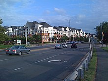
The Mosaic District is a mixed-use complex in the format of an ersatz downtown, with buildings lining urban-style streets.
See also[edit]
References[edit]
- ^ a b "U.S. Census website". United States Census Bureau. Retrieved January 31, 2008.
- ^ "US Board on Geographic Names". United States Geological Survey. October 25, 2007. Retrieved January 31, 2008.
- ^ a b c d e "Explore Census Data". data.census.gov. Retrieved January 23, 2024.
- ^ "US Gazetteer files: 2010, 2000, and 1990". United States Census Bureau. February 12, 2011. Retrieved April 23, 2011.
- ^ a b "Geographic Identifiers: 2010 Demographic Profile Data (G001): Merrifield CDP, Virginia". U.S. Census Bureau, American Factfinder. Retrieved October 14, 2016.[dead link]
- ^ "2010 Census Block Maps Merrifield, Virginia." U.S. Census Bureau. Retrieved on November 28, 2012.
- ^ Contact Us. Fairfax County Public Schools. Retrieved on November 28, 2012. "Gatehouse Administration Center 8115 Gatehouse Road Falls Church, VA 22042"


 French
 Deutsch


