
 French
 Deutsch
Mount Aetna (Colorado)
| Mount Aetna | |
|---|---|
 South aspect | |
| Highest point | |
| Elevation | 13,745 ft (4,189 m)[1][2] |
| Prominence | 1,225 ft (373 m)[2] |
| Parent peak | Mount Antero (14,276 ft)[3] |
| Isolation | 4.15 mi (6.68 km)[2] |
| Coordinates | 38°35′11″N 106°19′14″W / 38.5863437°N 106.3206359°W[4] |
| Geography | |
 Mount Aetna Location in Colorado  Mount Aetna Mount Aetna (the United States) | |
| Country | United States |
| State | Colorado |
| County | Chaffee County |
| Protected area | San Isabel National Forest |
| Parent range | Rocky Mountains Sawatch Range |
| Topo map | USGS Garfield |
| Geology | |
| Age of rock | Tertiary[5] |
| Type of rock | Quartz Monzonite Porphyry[5] |
| Climbing | |
| Easiest route | class 2 hiking[6] |
Mount Aetna is a 13,745-foot (4,189 m) mountain summit in Chaffee County, Colorado, United States.
Description[edit]
Mount Aetna is set 1.5 miles (2.4 km) east of the Continental Divide in the Sawatch Range which is a subrange of the Rocky Mountains. The prominent mountain is located 19 miles (31 km) west of the community of Salida on land managed by San Isabel National Forest. It ranks as the 129th-highest peak in Colorado.[6] Precipitation runoff from the mountain's slopes drains to the South Arkansas River. Topographic relief is significant as the summit rises 2,750 feet (838 m) above the river's Middle Fork in one mile (1.6 km). An ascent of the peak involves hiking nine miles (14 km) with 4,800 feet (1,463 m) of elevation gain.[1] Mount Aetna can be seen from Highway 50 at Monarch Pass.
Etymology[edit]
The mountain is named for its symmetrical profile resemblance to Mount Etna, the famous volcano in Sicily.[7] A visually prominent talus gully on the south slope of the mountain creates an illusion of lava flowing down this pseudo-volcanic peak.[5] The mountain's toponym has been officially adopted by the United States Board on Geographic Names,[4] and has been featured in publications since at least 1910, if not earlier.[8]
Climate[edit]
According to the Köppen climate classification system, Mt. Aetna is located in an alpine subarctic climate zone with cold, snowy winters, and cool to warm summers.[9] Due to its altitude, it receives precipitation all year, as snow in winter, and as thunderstorms in summer, with a dry period in late spring.
See also[edit]
Gallery[edit]
-
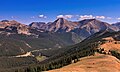 South aspect of Mt. Aetna (center) and Taylor Mountain from Monarch Ridge
 -
 South aspect of Mt. Aetna (left) and Taylor Mountain from Monarch Pass
 -
 Mt. Aetna (left) and Taylor Mountain (right)
 -
 Mt. Aetna (left) and Taylor Mountain (right)
 -
 Mt. Aetna seen from Monarch Pass
 -
 Mt. Aetna (left) from Monarch Pass


References[edit]
- ^ a b Mike Garratt, Bob Martin (1984), Colorado's High Thirteeners, Johnson Books, ISBN 9780917895395, p. 60
- ^ a b c "Mount Aetna, Colorado". Peakbagger.com. Retrieved April 5, 2023.
- ^ "Mount Aetna, Peakvisor.com". Retrieved April 5, 2023.
- ^ a b "Mount Aetna". Geographic Names Information System. United States Geological Survey, United States Department of the Interior. Retrieved April 5, 2023.
- ^ a b c USGS, Geology of the Mount Aetna volcanic center, Chaffee and Gunnison Counties, Colorado, January 1, 1994, p. 2.
- ^ a b "Aetna, Mount – 13,747' CO". listsofjohn.com. Retrieved April 5, 2023.
- ^ Jeff Rennicke (1986), Colorado Mountain Ranges, Falcon Press, ISBN 9780934318662
- ^ Colorado Geological Survey (1910), Bulletin – Colorado Geological Survey, p. 22.
- ^ Peel, M. C.; Finlayson, B. L.; McMahon, T. A. (2007). "Updated world map of the Köppen−Geiger climate classification". Hydrol. Earth Syst. Sci. 11. ISSN 1027-5606.
External links[edit]
- Mount Aetna: weather forecast
- Mt. Aetna (photo): Flickr