
 French
 Deutsch
Mount Lewis (California)
| Mount Lewis | |
|---|---|
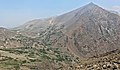
 East aspect | |
| Highest point | |
| Elevation | 12,350 ft (3,764 m)[1] |
| Prominence | 1,200 ft (370 m)[2] |
| Parent peak | Kuna Peak (13,002 ft)[3] |
| Isolation | 2.00 mi (3.22 km)[3] |
| Listing | Vagmarken Club Sierra Crest List[4] |
| Coordinates | 37°50′33″N 119°11′23″W / 37.8425738°N 119.1897518°W[1] |
| Dimensions | |
| Length | 3 mi (4.8 km) North-South |
| Width | 2 mi (3.2 km) East-West |
| Naming | |
| Etymology | Washington Bartlett "Dusty" Lewis |
| Geography | |
 Mount Lewis Location in California  Mount Lewis Mount Lewis (the United States) | |
| Location | Ansel Adams Wilderness Mono County, California, U.S. |
| Parent range | Sierra Nevada |
| Topo map | USGS Koip Peak |
| Geology | |
| Age of rock | Cretaceous |
| Mountain type | Fault block |
| Type of rock | Metamorphic rock,[5] Granodiorite |
| Climbing | |
| First ascent | Unknown[6] |
| Easiest route | class 2[3] West slope |
Mount Lewis is a 12,350-foot-elevation (3,764 meter) mountain summit located along the crest of the Sierra Nevada mountain range, in Mono County of northern California, United States.[1] It is situated in the Ansel Adams Wilderness, on land managed by Inyo National Forest. The summit lies less than one mile outside of Yosemite National Park's eastern boundary, and some of the lower western slope lies within the park. The mountain rises 1.8 miles (2.9 km) southeast of Mono Pass, 1.5 miles (2.4 km) northeast of Parker Pass, and two miles north of Parker Peak, which is the nearest higher neighbor.[2] Topographic relief is significant as it rises over 5,200 feet (1,600 meters) above Grant Lake in four miles which makes the mountain visible from Highway 395.
Etymology[edit]

The mountain is named in memory of Washington Bartlett "Dusty" Lewis (1884–1930), Superintendent of Yosemite National Park for 11 years from 1917 through 1928.[1][7] He played a leading part in the development of the park and in standardizing uniforms for National Park Service employees. This geographical feature's name was officially adopted in 1930 by the U.S. Board on Geographic Names.[1] Prior to 1930 this landform was known as Johnson Peak.[1]
Climate[edit]
According to the Köppen climate classification system, Mount Lewis is located in an alpine climate zone.[8] Most weather fronts originate in the Pacific Ocean, and travel east toward the Sierra Nevada mountains. As fronts approach, they are forced upward by the peaks (orographic lift), causing them to drop their moisture in the form of rain or snowfall onto the range. Precipitation runoff from this mountain drains into headwaters of Parker and Walker Creeks, both of which are tributaries of Rush Creek, which empties into Mono Lake.
Gallery[edit]
-
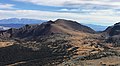 West aspect seen from Mammoth Peak
 -
 North aspect of Mt. Lewis from Mono Pass Trail
 -
 Mount Wood, Parker Peak, Koip Peak, and Mount Lewis (right)
 -
 Mt. Lewis above Lower Sardine Lake
 -
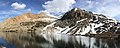 Mt. Lewis rises above Lower Sardine Lake (summit centered in back)
 -
 W. B. Lewis circa 1926
 -
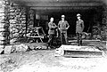 Daniel Hull, Stephen T. Mather, and W. B. Lewis in 1924
 -
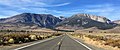 Mt. Lewis (right) seen from Highway 158
 -
 South aspect of Mt. Lewis (right) seen from Koip Peak Pass, (Parker Pass to left).


.jpg)


See also[edit]
References[edit]
- ^ a b c d e f "Mount Lewis". Geographic Names Information System. United States Geological Survey, United States Department of the Interior. Retrieved 2022-06-08.
- ^ a b "Mount Lewis, California". Peakbagger.com. Retrieved 2022-06-08.
- ^ a b c "Lewis, Mount - 12,324' CA". listsofjohn.com. Retrieved 2022-06-08.
- ^ "Vagmarken Sierra Crest List". Angeles Chapter, Sierra Club. Retrieved 2022-06-08.
- ^ Mary Hill (2006), Geology of the Sierra Nevada, University of California Press, ISBN 9780520936942, p. 174.
- ^ Edward S. Robbins and Alfred W. Baxter, Jr., A Climber’s Guide to the High Sierra, (1954)
- ^ John W. Bingaman, Guardians of the Yosemite (1961)
- ^ "Climate of the Sierra Nevada". Encyclopædia Britannica.
External links[edit]
- Weather forecast: Mount Lewis
- Mt. Lewis (photo): Flickr
Places adjacent to Mount Lewis (California) | ||||||||||||||||
|---|---|---|---|---|---|---|---|---|---|---|---|---|---|---|---|---|
| ||||||||||||||||