
 French
 Deutsch
Mount McCaleb
| Mount McCaleb | |
|---|---|
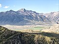
 South aspect, in winter | |
| Highest point | |
| Elevation | 11,682 ft (3,561 m)[1] |
| Prominence | 682 ft (208 m)[2] |
| Parent peak | USGS Peak (11,982 ft)[3] (aka McCaleb Benchmark) |
| Isolation | 1.56 mi (2.51 km)[3] |
| Coordinates | 43°59′38″N 113°35′53″W / 43.9938555°N 113.5980196°W[4] |
| Naming | |
| Etymology | Capt. Jesse Burton McCaleb |
| Geography | |
 Mount McCaleb Location in Idaho  Mount McCaleb Mount McCaleb (the United States) | |
| Location | Salmon–Challis National Forest |
| Country | United States of America |
| State | Idaho |
| County | Custer |
| Parent range | Lost River Range Rocky Mountains |
| Topo map | USGS Mackay |
| Geology | |
| Age of rock | Mississippian[5] |
| Mountain type | Fault block |
| Type of rock | Limestone[5] |
| Climbing | |
| First ascent | 1884 by J.D. Martin[6] |
| Easiest route | class 3 scrambling[3] |
Mount McCaleb is an 11,682-foot elevation (3,561 m) mountain summit located in Custer County, Idaho, United States.
Description[edit]
Mount McCaleb ranks as the 33rd-highest peak in Idaho and is part of the Lost River Range which is a subset of the Rocky Mountains.[3] The mountain is set on land managed by Salmon–Challis National Forest and the peak overlooks the town of Mackay which is situated 6.5 miles south of the peak. Neighbors include Mount Breitenbach, 6.6 miles to the northwest, line parent USGS Peak 1.6 mile to the northeast, and Borah Peak, the highest peak in Idaho, is 13 miles to the northwest.[2] Precipitation runoff from the mountain's slopes drains to Big Lost River. Topographic relief is significant as the summit rises 5,000 feet (1,500 meters) above Big Lost River Valley in three miles.
Etymology[edit]
This mountain's toponym has been officially adopted by the United States Board on Geographic Names.[4] The name honors Jesse McCaleb (1837–1878), heroic pioneer, merchant from Challis, and business associate of George L. Shoup.[7] Jesse McCaleb was killed August 11, 1878, during an attack by Indians north of Mackay below this mountain which now bears his name.[8]
Climate[edit]
Based on the Köppen climate classification, Mt. McCaleb is located in an alpine subarctic climate zone with long, cold, snowy winters, and cool to warm summers.[9] Winter temperatures can drop below −10 °F with wind chill factors below −30 °F.
Gallery[edit]
-
 West aspect
 -
 South aspect
 -
 Mt. McCaleb to the right
 -
 Mt. McCaleb in the distance
 -
 Mount McCaleb and Big Lost River Valley
 -
 Mt. McCaleb
.jpg)
.jpg)


See also[edit]
References[edit]
- ^ United States Geological Survey topographical map - Mackay
- ^ a b "Mount McCaleb, Idaho". Peakbagger.com. Retrieved 2022-09-01.
- ^ a b c d "McCaleb, Mount - 11,682' ID". listsofjohn.com. Retrieved 2022-09-01.
- ^ a b "Mount McCaleb". Geographic Names Information System. United States Geological Survey, United States Department of the Interior. Retrieved 2022-09-01.
- ^ a b Jeffrey Lee, James P. Evans (2011), Geologic Field Trips to the Basin and Range, Rocky Mountains, Snake River Plain, and Terranes of the U.S. Cordillera, Geological Society of America, p. 118
- ^ Idaho: A Climbing Guide, Mount McCaleb
- ^ Missions, Volume II (1920), American Baptist Convention, p. 221
- ^ History of Idaho Territory, 1884, Wallace W. Elliott & Co., p. 250
- ^ Peel, M. C.; Finlayson, B. L.; McMahon, T. A. (2007). "Updated world map of the Köppen−Geiger climate classification". Hydrol. Earth Syst. Sci. 11: 1633–1644. ISSN 1027-5606.
External links[edit]
- Mount McCaleb: weather forecast
- Mount McCaleb: Idaho: A Climbing Guide
- Jesse McCaleb: biography and image
- Mount McCaleb (photo): Flickr