This is a list of Registered Historic Places in Barrington , Rhode Island National Register of Historic Places listings in Bristol County, Rhode Island
This National Park Service list is complete through NPS recent listings posted April 12, 2024. [1] [2] Name on the Register[3] Image Date listed[4] Location City or town Description 1 Alfred Drowne Road Historic District Alfred Drowne Road Historic District June 10, 2005 (#05000584 ) Alfred Drowne Rd., Annawamscutt Rd., Washington Rd. 41°44′38″N 71°20′38″W / 41.743889°N 71.343889°W / 41.743889; -71.343889 (Alfred Drowne Road Historic District ) Barrington 2 Allen-West House Allen-West House December 3, 2013 (#13000887 ) 153 George St. 41°46′19″N 71°18′44″W / 41.771912°N 71.31229°W / 41.771912; -71.31229 (Allen-West House ) Barrington 3 Barrington Civic Center Barrington Civic Center December 12, 1976 (#76000198 ) County Rd. 41°44′29″N 71°18′33″W / 41.741389°N 71.309167°W / 41.741389; -71.309167 (Barrington Civic Center ) Barrington 4 Belton Court Belton Court June 30, 1976 (#76000037 ) Middle Highway 41°45′36″N 71°19′57″W / 41.76°N 71.3325°W / 41.76; -71.3325 (Belton Court ) Barrington 5 Benjamin Aborn Jackson House Benjamin Aborn Jackson House September 19, 2008 (#08000903 ) 115 Nayatt Rd. 41°43′34″N 71°19′58″W / 41.726133°N 71.332703°W / 41.726133; -71.332703 (Benjamin Aborn Jackson House ) Barrington 6 Jennys Lane Historic District Jennys Lane Historic District March 6, 2008 (#08000152 ) Jennys Ln. and Mathewson and Rumstick Rds. 41°44′04″N 71°17′58″W / 41.734541°N 71.299406°W / 41.734541; -71.299406 (Jennys Lane Historic District ) Barrington 7 Nayatt Point Lighthouse Nayatt Point Lighthouse February 25, 1988 (#87001694 ) Nayatt Point 41°43′30″N 71°20′23″W / 41.725°N 71.339722°W / 41.725; -71.339722 (Nayatt Point Lighthouse ) Barrington 8 O'Bannon Mill O'Bannon Mill July 23, 1996 (#96000891 ) 90 Bay Spring Ave. 41°44′50″N 71°20′43″W / 41.747222°N 71.345278°W / 41.747222; -71.345278 (O'Bannon Mill ) Barrington 9 St. Matthew's Episcopal Church St. Matthew's Episcopal Church August 22, 1991 (#91001024 ) 5 Chapel Rd. 41°44′34″N 71°20′37″W / 41.742778°N 71.343611°W / 41.742778; -71.343611 (St. Matthew's Episcopal Church ) Barrington
See also [ edit ] References [ edit ] ^ National Park Service, United States Department of the Interior , "National Register of Historic Places: Weekly List Actions" , retrieved April 12, 2024. ^ Numbers represent an alphabetical ordering by significant words. Various colorings, defined here , differentiate National Historic Landmarks and historic districts from other NRHP buildings, structures, sites or objects. ^ "National Register Information System" . National Register of Historic Places National Park Service . March 13, 2009.^ The eight-digit number below each date is the number assigned to each location in the National Register Information System database, which can be viewed by clicking the number.
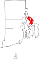
Towns Map of Rhode Island highlighting Bristol County
Topics Lists by county Lists by city
Bristol County Kent County Newport County Providence County Washington County

 French
 Deutsch