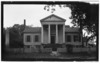
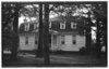
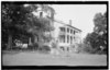
[3] Name on the Register Image Date listed[4] Location City or town Description 1 Belvidere Belvidere August 2, 1977 (#77001008 ) NC 37, W of Perquimans River 36°16′08″N 76°32′48″W / 36.268889°N 76.546667°W / 36.268889; -76.546667 (Belvidere ) Belvidere 2 Belvidere Historic District Upload image June 4, 1999 (#99000600 ) Roughly bounded by the Perquinmans R., NC 37, NC 1200, and NC 1213 36°16′08″N 76°32′17″W / 36.268889°N 76.538056°W / 36.268889; -76.538056 (Belvidere Historic District ) Belvidere 3 Church of the Holy Trinity Church of the Holy Trinity June 11, 1998 (#98000688 ) 207 S. Church St. 36°11′14″N 76°28′00″W / 36.187222°N 76.466667°W / 36.187222; -76.466667 (Church of the Holy Trinity ) Hertford 4 Cove Grove Cove Grove August 7, 1974 (#74001366 ) E of Hertford near SR 1301 and 1302 36°11′02″N 76°25′02″W / 36.183889°N 76.417222°W / 36.183889; -76.417222 (Cove Grove ) Hertford 5 Fletcher-Skinner-Nixon House and Outbuildings Fletcher-Skinner-Nixon House and Outbuildings January 21, 1994 (#93001541 ) NC 1301 NE side, 0.45 miles SE of jct. with NC 1300 36°11′45″N 76°25′45″W / 36.195833°N 76.429167°W / 36.195833; -76.429167 (Fletcher-Skinner-Nixon House and Outbuildings ) Hertford 6 Hertford Historic District Hertford Historic District October 22, 1998 (#98001264 ) Roughly bounded by the Perquimans River and W. Academy St., Hyde St., and Dobbs St. 36°11′23″N 76°28′04″W / 36.189722°N 76.467778°W / 36.189722; -76.467778 (Hertford Historic District ) Hertford 7 Jonathan Hill Jacocks House Upload image April 1, 1998 (#98000276 ) Jct. of New Hope Rd. and Jacocks Ln. 36°08′47″N 76°15′59″W / 36.146389°N 76.266389°W / 36.146389; -76.266389 (Jonathan Hill Jacocks House ) New Hope Township 8 Land's End Land's End September 20, 1973 (#73001365 ) SE of Hertford near jct. of SR 1300 and 1324 36°06′40″N 76°13′17″W / 36.111111°N 76.221389°W / 36.111111; -76.221389 (Land's End ) Hertford Home of Col. James Leigh (1781-1854) 9 Mitchell-Ward House Mitchell-Ward House June 25, 1999 (#99000716 ) Jct. NC 1119 and NC 1002 36°16′30″N 76°34′05″W / 36.275°N 76.568056°W / 36.275; -76.568056 (Mitchell-Ward House ) Belvidere 10 Myers-White House Myers-White House January 20, 1972 (#72000986 ) NE of Bethel on SR 1347 36°07′12″N 76°26′58″W / 36.120094°N 76.449486°W / 36.120094; -76.449486 (Myers-White House ) Bethel 11 Newbold-White House Newbold-White House June 24, 1971 (#71000615 ) SE of Hertford off SR 1336 36°10′00″N 76°26′15″W / 36.166667°N 76.4375°W / 36.166667; -76.4375 (Newbold-White House ) Hertford 12 Samuel Nixon House Upload image October 15, 1973 (#73001366 ) NW of Hertford on SR 1121 36°13′03″N 76°29′45″W / 36.2175°N 76.495833°W / 36.2175; -76.495833 (Samuel Nixon House ) Hertford 13 Old Neck Historic District Upload image September 6, 1996 (#96000929 ) Roughly bounded by US 17, NC 1302, NC 1300, Suttons Cr., and the Perquimans River 36°11′33″N 76°25′07″W / 36.1925°N 76.418611°W / 36.1925; -76.418611 (Old Neck Historic District ) Hertford 14 Perquimans County Courthouse Perquimans County Courthouse May 10, 1979 (#79001743 ) Church St. 36°11′21″N 76°27′55″W / 36.189167°N 76.465278°W / 36.189167; -76.465278 (Perquimans County Courthouse ) Hertford 15 Stockton Stockton June 7, 1974 (#74001368 ) S of Woodville 36°12′57″N 76°19′06″W / 36.215833°N 76.318333°W / 36.215833; -76.318333 (Stockton ) Woodville 16 Sutton-Newby House Sutton-Newby House September 10, 1974 (#74001367 ) E of Hertford 36°11′16″N 76°22′56″W / 36.187778°N 76.382222°W / 36.187778; -76.382222 (Sutton-Newby House ) Hertford 17 Isaac White House Isaac White House March 23, 1979 (#79001742 ) NE of Bethel on SR 1339 36°07′38″N 76°27′39″W / 36.127281°N 76.460828°W / 36.127281; -76.460828 (Isaac White House ) Bethel 18 Winfall Historic District Upload image January 15, 2003 (#02001715 ) Roughly along Main St. and Wiggins Rd. 36°13′11″N 76°27′43″W / 36.219722°N 76.461944°W / 36.219722; -76.461944 (Winfall Historic District ) Winfall 
 French
 Deutsch


.jpg)


.JPG)