
 French
 Deutsch
Neve Glacier
| Neve Glacier | |
|---|---|
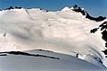
 View of Neve Glacier at right from the northeast as seen in 1971. The smaller Colonial Glacier is at left. | |
 Neve Glacier Location in Washington | |
| Type | Alpine glacier |
| Location | Skagit and Whatcom County, Washington, U.S. |
| Coordinates | 48°38′46″N 121°08′28″W / 48.64611°N 121.14111°W[1] |
| Length | 1.80 mi (2.90 km) |
| Terminus | Barren rock |
| Status | Retreating |
Neve Glacier is in North Cascades National Park in the U.S. state of Washington and is on the north slopes of Snowfield Peak. Neve Glacier flows generally north and splits in two with two terminal tongues, one flowing to the northwest which is known as Ladder Creek Glacier and the other descending a total of more than 1.8 mi (2.9 km) to the east. Ladder Creek Glacier descends from 7,800 to 6,000 ft (2,400 to 1,800 m), while the east tongue also originates from the same altitude and descends to 5,600 ft (1,700 m).[2] Between 1850 and 2006, Neve Glacier is estimated to have retreated more than 1,000 m (3,300 ft).[3]
See also[edit]
Gallery[edit]
-
 Neve Glacier and Snowfield Peak (left) seen from Ruby Mountain
 -
 Neve Glacier seen from Neve Peak


Notes[edit]
- ^ "Neve Glacier". Geographic Names Information System. United States Geological Survey, United States Department of the Interior. Retrieved March 17, 2013.
- ^ Diablo Dam, WA (Map). TopoQuest (United States Geological Survey Maps). Retrieved March 17, 2013.
- ^ Pelto, Mauri. "North Cascade Glacier Retreat". Nichols College. Archived from the original on October 22, 2012. Retrieved March 17, 2013.
References[edit]
- "Geological Survey Professional Paper 715—A". National Park Service. Retrieved 2017-12-19.
This article about a glacier in Washington is a stub. You can help Wikipedia by expanding it. |