
 French
 Deutsch
Puerto Rico Highway 128
Highway 128 | ||||
|---|---|---|---|---|
| Ruta 128 | ||||
| Route information | ||||
| Maintained by Puerto Rico DTPW | ||||
| Length | 58.7 km[1] (36.5 mi) | |||
| Existed | 1953[2]–present | |||
| Major junctions | ||||
| South end | ||||
| North end | ||||
| Location | ||||
| Country | United States | |||
| Territory | Puerto Rico | |||
| Municipalities | Yauco, Maricao, Lares | |||
| Highway system | ||||
| ||||
| ||||

Puerto Rico Highway 128 (PR-128) is a road that travels from Yauco, Puerto Rico to Lares.[3] This highway extends from PR-2 in Yauco and ends at PR-111 near downtown Lares.[4][5]
Major intersections[edit]
-
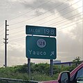 PR-2 west at exit 198 to PR-128 in Yauco
 -
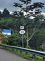 PR-128 north approaching PR-1111 in Lares
 -
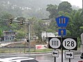 Signs for Puerto Rico Highways 111, 128 and 1111 in Lares


| Municipality | Location | km[1] | mi | Destinations | Notes |
|---|---|---|---|---|---|
| Yauco | Susúa Baja | 0.0 | 0.0 | Southern terminus of PR-128; PR-2 exit 198; diamond interchange | |
| 0.5– 0.6 | 0.31– 0.37 | ||||
| 1.4– 1.5 | 0.87– 0.93 | ||||
| Susúa Baja–Almácigo Bajo line | 1.8– 1.9 | 1.1– 1.2 | |||
| Almácigo Bajo | 2.2 | 1.4 | |||
| Almácigo Bajo–Diego Hernández line | 3.1– 3.2 | 1.9– 2.0 | |||
| 3.3– 3.4 | 2.1– 2.1 | ||||
| Naranjo | 12.8 | 8.0 | |||
| Rubias | 24.5 | 15.2 | |||
| Maricao | Indiera Alta | 25.7 | 16.0 | Southern terminus of the Ruta Panorámica concurrency; the Ruta Panorámica continues toward Sabana Grande | |
| 33.1 | 20.6 | ||||
| 33.1 | 20.6 | Puente de Río Prieto over the Río Prieto[6] | |||
| Lares | Bartolo | 36.8 | 22.9 | ||
| 37.9 | 23.5 | Northern terminus of the Ruta Panorámica concurrency | |||
| 40.6 | 25.2 | ||||
| La Torre | 44.3 | 27.5 | |||
| Río Blanco | 47.5 | 29.5 | Puente del Río Blanco[6] | ||
| La Torre–Mirasol– Buenos Aires tripoint | 52.6 | 32.7 | |||
| Buenos Aires–La Torre line | 54.6 | 33.9 | Former PR-431 | ||
| Lares barrio-pueblo | 58.7 | 36.5 | Northern terminus of PR-128 | ||
1.000 mi = 1.609 km; 1.000 km = 0.621 mi
| |||||
Related route[edit]
Highway 4128 | |
|---|---|
| Location | Lares |
| Length | 1.2 km[7] (0.75 mi) |
Puerto Rico Highway 4128 (PR-4128) is a bypass road that branches off from PR-128 and ends at PR-111 west of downtown Lares.[3] The entire route is located in Lares barrio-pueblo, Lares.
| km[7] | mi | Destinations | Notes | ||
|---|---|---|---|---|---|
| 1.2 | 0.75 | Western terminus of PR-4128 | |||
| 0.0 | 0.0 | Eastern terminus of PR-4128 | |||
| 1.000 mi = 1.609 km; 1.000 km = 0.621 mi | |||||
See also[edit]
References[edit]
- ^ a b Google (6 March 2020). "PR-128" (Map). Google Maps. Google. Retrieved 6 March 2020.
- ^ "Lares, Memoria Núm. 60" (PDF). Puerto Rico Planning Board (in Spanish). 1955. Retrieved 4 August 2020.
- ^ a b National Geographic Maps (2011). Puerto Rico (Map). 1:125,000. Adventure Map (Book 3107). Evergreen, Colorado: National Geographic Maps. ISBN 978-1566955188. OCLC 756511572.
- ^ "Tránsito Promedio Diario (AADT)". Puerto Rico Department of Transportation and Public Works (in Spanish). pp. 73–74. Archived from the original on 1 April 2019. Retrieved 31 May 2019.
- ^ "Map of Adjuntas at the Wayback Machine" (PDF). Archived from the original (PDF) on 17 April 2015. Retrieved 29 December 2018.
- ^ a b Luis F. Pumarada O’Neill (1991). "Los Puentes Históricos de Puerto Rico" (PDF) (in Spanish). Retrieved 10 March 2020.
- ^ a b Google (1 March 2020). "PR-4128" (Map). Google Maps. Google. Retrieved 1 March 2020.
External links[edit]
This Puerto Rico road-related article is a stub. You can help Wikipedia by expanding it. |