
 French
 Deutsch
Roughlee Booth
| Roughlee Booth | |
|---|---|
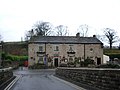
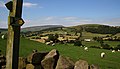
 A view over Roughlee | |
 Roughlee Booth Location within Lancashire | |
| Area | 4.49 km2 (1.73 sq mi) [1] |
| Population | 318 [1] |
| • Density | 71/km2 (180/sq mi) |
| Civil parish |
|
| District | |
| Shire county | |
| Region | |
| Country | England |
| Sovereign state | United Kingdom |
| Postcode district | BB9,BB12 |
| Dialling code | 01282 |
| Website | Roughlee Parish Council |

Roughlee Booth is a civil parish located in Pendle, Lancashire. It is approximately 449.43 hectares in size[2] and situated in the Forest of Bowland AONB.[3] It borders on the parishes of Blacko, Barrowford, Old Laund Booth, Goldshaw Booth and Barley-with-Wheatley Booth. It is part of the Forest of Bowland Area of Outstanding Natural Beauty (AONB).[4] It contains the village of Roughlee and hamlets of Crow Trees and Thornley Holme. According to the United Kingdom Census 2011, the parish has a population of 318,[1] a decrease from 328 in the 2001 census.[5]
Governance[edit]
Along with Higham-with-West Close Booth, Goldshaw Booth and Barley-with-Wheatley Booth, the parish forms the Higham with Pendleside ward of Pendle Borough Council.[6]
Roughlee Booth was once a township in the ancient parish of Whalley. This became a civil parish in 1866, forming part of the Burnley Rural District from 1894 until 1974. The village of Newchurch in Pendle used to straddle the boundary with Goldshaw Booth,[a] but that part of the parish was transferred in 1935.[8]
Media gallery[edit]
-
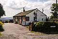
 The Bay Horse public house in Roughlee village
 -
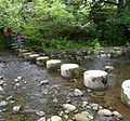 Stepping stones over Pendle Water near Roughlee Old Hall
 -
 Noggarth Tea Gardens
 -
 Thornley Holme, on the road to Barley
 -
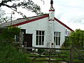 Clarion House, home of the Nelson Independent Labour Party Land Society
 -
 The Pendle Way passes through the parish
 -
 Blacko Water in the east of the parish

.jpg)

.jpg)


.jpg)
See also[edit]
References[edit]
- ^ a b c UK Census (2011). "Local Area Report – Roughlee Booth Parish (1170215075)". Nomis. Office for National Statistics. Retrieved 11 February 2018.
- ^ "Office for National Statistics- geography linked data". statistics.data.gov.uk.
- ^ "Forest of Bowland Map". forestofbowland.com.
- ^ Forest of Bowland map (Map). forestofbowland.com. Lancashire County Council.
- ^ Office for National Statistics : Census 2001 : Parish Headcounts : Pendle Retrieved 2009-09-18
- ^ "Higham with Pendleside". Ordnance Survey Linked Data Platform. Ordnance Survey. Retrieved 2 September 2015.
- ^ Lancashire and Furness (Map) (1st ed.). 1 : 10,560. County Series. Ordnance Survey. 1848.
- ^ "Roughlee Booth Tn/CP through time". visionofbritain.org.uk. GB Historical GIS / University of Portsmouth. Retrieved 3 September 2015.
Notes
- ^ In 1848, the boundary passed just east of St Mary's Church.[7]
External links[edit]