
 French
 Deutsch
Schiestler Peak
| Schiestler Peak | |
|---|---|
 Northeast aspect | |
| Highest point | |
| Elevation | 11,624 ft (3,543 m)[1][2] |
| Prominence | 384 ft (117 m)[1] |
| Parent peak | A Cheval Peak (11,763 ft)[3] |
| Isolation | 1.14 mi (1.83 km)[3] |
| Coordinates | 42°43′32″N 109°12′03″W / 42.72556°N 109.20083°W[4] |
| Naming | |
| Etymology | Felix Schiestler |
| Geography | |
 Schiestler Peak Location in Wyoming  Schiestler Peak Schiestler Peak (the United States) | |
| Location | Sublette County, Wyoming, U.S. |
| Parent range | Wind River Range |
| Topo map | USGS Temple Peak |
| Geology | |
| Type of rock | granitic |
| Climbing | |
| First ascent | August 11, 1933 by Finis Mitchell[5] |
| Easiest route | class 2[3] Southwest slope |
Schiestler Peak is an 11,624-foot-elevation (3,543-meter) mountain summit located in Sublette County of Wyoming, United States.[4]
Description[edit]
The peak is situated in the remote Wind River Range, three miles west of the Continental Divide, and approximately four miles south of the Cirque of the Towers. It is set in the Bridger Wilderness, on land managed by Bridger-Teton National Forest. Topographic relief is significant as the northeast aspect rises 2,000 feet (610 meters) in one-half mile. Nearby geographic features include Haystack Mountain, 1.9 mile to the east, Big Sandy Lake one mile north, and Temple Peak 2.3 miles to the southeast. Access to the mountain is via the Big Sandy Trail. Molybdenum was discovered on the mountain around 1940, and several claims were staked, but little ore was extracted.[6][7] Precipitation runoff from the mountain drains into headwaters of the Big Sandy River, which is a tributary of the Green River.
Etymology[edit]
The peak's name honors Felix Schiestler (1855–1924), pioneer resident of Rock Springs, Wyoming.[8] He immigrated to the United States from Austria, and after spending ten years in the east, he arrived in Rock Springs in 1886. He engaged in sheep raising, succeeding to such an extent that he was considered one of the leading flockmasters of Sweetwater County at the time of his death.[9]
Climate[edit]
According to the Köppen climate classification system, Schiestler Peak is located in an alpine subarctic climate zone with long, cold, snowy winters, and cool to warm summers.[10] Due to its altitude, it receives precipitation all year, as snow in winter, and as thunderstorms in summer.
Hazards[edit]
Encountering bears is a concern in the Wind River Range.[11] There are other concerns as well, including bugs, wildfires, adverse snow conditions and nighttime cold temperatures.[12]
Importantly, there have been notable incidents, including accidental deaths, due to falls from steep cliffs (a misstep could be fatal in this class 4/5 terrain) and due to falling rocks, over the years, including 1993,[13] 2007 (involving an experienced NOLS leader),[14] 2015[15] and 2018.[16] A 54-year-old climber from Durango fell 400–800 feet to his death from nearby Steeple Peak in 2017.[17] Other incidents include a seriously injured backpacker being airlifted near Squaretop Mountain[18] in 2005,[19] and a fatal hiker incident (from an apparent accidental fall) in 2006 that involved state search and rescue.[20] The U.S. Forest Service does not offer updated aggregated records on the official number of fatalities in the Wind River Range.
Gallery[edit]
-
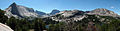 Haystack Mountain (left), Temple Peak centered in back, Schiestler Peak (right)
 -
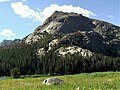 North aspect
 -
 North aspect
 -
 Left to rightː Haystack Mountain, East Temple Peak, Temple Peak, Schiestler Peak


See also[edit]
References[edit]
- ^ a b "Schiestler Peak, Wyoming". Peakbagger.com. Retrieved 2021-07-28.
- ^ Ben Adkison, Hiking Wyoming's Wind River Range, 2018, Falcon Guides, ISBN 9781493034642, page 157.
- ^ a b c "Schiestler Peak - 11,660' WY". listsofjohn.com. Retrieved 2021-07-28.
- ^ a b "Schiestler Peak". Geographic Names Information System. United States Geological Survey, United States Department of the Interior. Retrieved 2021-07-28.
- ^ Joe Kelsey, 2013, Climbing and Hiking in the Wind River Mountains, Falcon Guides, ISBN 9781493001354, page 430.
- ^ Geological Survey Bulletin, US Government Printing Office, 1971, page B33.
- ^ Schiestler Peak molybdenum prospect, Westernmininghistory.com
- ^ Orrin H. Bonney, Lorraine G. Bonney, 1965, Guide to the Wyoming Mountains and Wilderness Areas, Sage Books, page 209.
- ^ Rock Springs Rocket, January 18, 1924, wygenweb.com
- ^ Peel, M. C.; Finlayson, B. L.; McMahon, T. A. (2007). "Updated world map of the Köppen−Geiger climate classification". Hydrol. Earth Syst. Sci. 11. ISSN 1027-5606.
- ^ Staff (April 24, 2017). "Bear Safety in Wyoming's Wind River Country". WindRiver.org. Retrieved February 17, 2019.
- ^ Ballou, Dawn (July 27, 2005). "Wind River Range condition update - Fires, trails, bears, Continental Divide". PineDaleOnline News. Retrieved February 17, 2019.
- ^ Staff (1993). "Falling Rock, Loose Rock, Failure to Test Holds, Wyoming, Wind River Range, Seneca Lake". American Alpine Club. Retrieved February 15, 2019.
- ^ MacDonald, Dougald (August 14, 2007). "Trundled Rock Kills NOLS Leader". Climbing. Retrieved February 15, 2019.
- ^ Staff (December 9, 2015). "Officials rule Wind River Range climbing deaths accidental". Casper Star-Tribune. Retrieved February 15, 2019.
- ^ Dayton, Kelsey (August 24, 2018). "Deadly underestimation". WyoFile News. Retrieved February 15, 2019.
- ^ Nick Learned, Climber Falls to His Death in Wyoming’s Wind River Range, August 31, 2017, k2radio.com
- ^ Funk, Jason (2009). "Squaretop Mountain Rock Climbing". Mountain Project. Retrieved March 29, 2019.
- ^ Staff (July 22, 2005). "Injured man rescued from Square Top Mtn - Tip-Top Search & Rescue helps 2 injured on the mountain". PineDaleOnline News. Retrieved February 17, 2019.
- ^ Staff (September 1, 2006). "Incident Reports - September, 2006 - Wind River Search". WildernessDoc.com. Retrieved February 17, 2019.
External links[edit]
- Weather forecast: Schiestler Peak