
 French
 Deutsch
Serayu River
| Serayu River Kali Serayu, Sungai Serayu, Ci Sarayu, Kali Seraju, Kali Serajoe, Chi Seraju, Serdju, Serajoe River | |
|---|---|
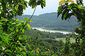
 Serayu river at Kebasen, Banyumas | |
 Location of river mouth  Serayu River (Indonesia) | |
| Location | |
| Country | Central Java, Indonesia |
| Physical characteristics | |
| Source | |
| • location | Dieng Volcanic Complex |
| • elevation | 2,100 m (6,900 ft) asl |
| Mouth | |
• location | Indian Ocean |
| Length | 181 km (112 mi) |
| Basin size | 4,375 km2 (1,689 sq mi) |
| Discharge | |
| • average | 415 m3/s (14,700 cu ft/s) |
The Serayu River is a river in Central Java, Indonesia, about 300 km southeast of the capital Jakarta.[1][2]
Hydrology[edit]
The river spanned from northeast to southwest with a length of around 181 km, and crossing five kabupaten (regency) in Central Java; they are Wonosobo Regency, Banjarnegara Regency, Purbalingga Regency, Banyumas Regency, draining to Indian Ocean with estuarine located at Cilacap Regency.[3]
Geography[edit]
The river flows in the southern central area of Java with a predominantly tropical monsoon climate (designated as Am in the Köppen-Geiger climate classification).[4] The annual average temperature in the area is 24 °C. The warmest month is March, when the average temperature is around 25 °C, and the coldest is August, at 23 °C.[5] The average annual rainfall is 3897 mm. The wettest month is January, with an average of 561 mm of rainfall, and the driest is September, with 34 mm of rainfall.[6]
Uses[edit]
Mrica Dam is a hydroelectric power dam installed in the Serayu River.[7][8]
Water rafting is one of the tourist attractions in the villages of Tunggara and Prigi, in Banjarnegara Regency.[9]
Gallery[edit]
-
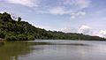
 Serayu river
 -
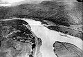
 Railroad construction by the Serayu near Kebasen, Banyumas
 -
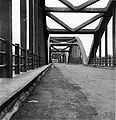
 Railroad bridge across Serayu near Kebasen
 -
 Bridge at Rawalo, Banyumas
 -
 Bridge near Maos, Cilacap (before 1917)
 -
 Bridge built in 1890
 -
 Serayu river


See also[edit]
- Sarayu River, in India, Sarayu and Serayu have been named after river in Hindu epic Ramayana
- Sunda Kingdom, Hindu kingdom of Central and Western Java through which this river flowed
- List of drainage basins of Indonesia
- List of rivers of Indonesia
- List of rivers of Java
References[edit]
- ^ Kali Serayu at Geonames.org (cc-by); Last updated 2013-06-04; Database dump downloaded 2015-11-27
- ^ Rand McNally, The New International Atlas, 1993.
- ^ Munir, A. 2009. Karakteristik daerah aliran sungai (DAS) Serayu Provinsi Jawa Tengah berdasarkan kondisi fisik, sosial, serta ekonomi. Dept. Geografi FMIPA Universitas Indonesia. (paper tidak diterbitkan)
- ^ Peel, M C; Finlayson, B L; McMahon, T A (2007). "Updated world map of the Köppen-Geiger climate classification". Hydrology and Earth System Sciences. 11 (5): 1633–1644. doi:10.5194/hess-11-1633-2007. Retrieved 30 January 2016.
- ^ "NASA Earth Observations Data Set Index". NASA. 30 January 2016.
- ^ "NASA Earth Observations: Rainfall (1 month - TRMM)". NASA/Tropical Rainfall Monitoring Mission. 30 January 2016.
- ^ Tempo.co: Usia Waduk Mrica Diperkirakan Tinggal 12 Tahun. Diakses 5/XII/2014.
- ^ Dinas Budpar Banjarnegara: Wisata Waduk Mrica. Diakses 5/XII/2014.
- ^ Kab. Banjarnegara: Arung Jeram Kaliserayu. Diakses 5/XII/2014.