
 French
 Deutsch
Sinks Canyon State Park
| Sinks Canyon State Park | |
|---|---|
 Looking west from the entrance of the canyon | |
 Sinks Canyon State Park Location in Wyoming | |
| Location | Fremont County, Wyoming, United States |
| Nearest city | Lander |
| Coordinates | 42°43′22″N 108°52′30″W / 42.72278°N 108.87500°W[1] |
| Area | 600 acres (240 ha)[2] |
| Elevation | 6,122 ft (1,866 m)[1] |
| Established | 1971 |
| Administered by | Wyoming State Parks, Historic Sites & Trails |
| Designation | Wyoming state park |
| Website | Official website |
Sinks Canyon State Park is a public recreation and nature preservation area located in the Wind River Mountains, six miles (9.7 km) southwest of Lander, Wyoming, on Wyoming Highway 131. The state park is named for a portion of the Middle Fork of the Popo Agie River where it flows into an underground limestone cavern, named "the Sinks," and emerges a quarter-mile down the canyon in a pool named "the Rise." The park is managed by the Wyoming Division of State Parks and Historic Sites.[3]
History[edit]
Human activity in Sinks Canyon goes back thousands of years. Archaeological digs have found hearths and tools carbon dated as far back as the last ice age. Since the late 19th century, the canyon and its river have been utilized for a variety of purposes. A saw mill, small hydroelectric dam and power plant, and ski area have all operated in the canyon.[4]
- Power plant

A hydroelectric dam and power plant were built in the canyon in the late 1910s by the Sinks Canyon Hydro Power Company and became operational by January 1920.[4][5] The purpose of the plant was to supply nearby Lander with more reliable electricity. Power generation was possible most of the year except during winter months because water levels become too low.[6] The design of the system consisted of a small stone-concrete dam standing 9 feet high and 60 feet wide built on the Popo Agie River a short distance upstream.[5] The dam connected to the power house located at the Rise via a 3,145 foot long riveted-steel pipeline with a diameter of between 30 and 26 inches.[6] The pipeline allowed water to flow at a rate of 17 feet per second until reaching the power house.[6] The power house contained two 47 inch 250 horsepower hug impulse wheels, each spun by two 3 inch diameter water nozzles.[6] The two wheels were controlled by two separate Lombard oil-pressure governors which were connected to a 150-kilowatt 3 phase 60 cycle alternating-current generator operating at 2,300 volts.[6] The power was transmitted at 11,000 volts over a copper circuit suspended by cedar poles to Lander and South Pass City as well as some oil extraction projects in the area.[6][5] The plant operated until around 1954 when it was shut down due to its age and cheaper sources of electricity becoming available.[4]
- State park
Large portions of the canyon were purchased by the state in 1939 and 1953 to be set aside as a wildlife habitat and to protect the fishery. In 1963, Pacific Power and Light Company donated the Rise and the seven acres surrounding it to the city of Lander for use as a park. In 1970, city and state officials working with the state legislature and private citizens created Sinks Canyon State Park, the first park created under the newly formed Wyoming Recreation Commission. The bill creating the park was signed in 1971. A new overlook was built at the Rise in 1972; the visitor center was completed in 1973.[4]
Natural history[edit]
- Geology
The Madison Limestone Formation was carved by glacial movement, leaving extensive underground fissures and steep cliff walls. The gradual recession of the ice left glacial moraines along the canyon floor. The canyon is the second most southerly of the many canyons along the eastern slope of the Wind River Range.[7]
- The Rise
The exact route of the passage is unknown, and dye tests have shown that the water takes over 2 hours to make its 1/4-mile underground journey. Additionally, more water flows from the Rise than enters the cavern at the Sink. The Crow Indian name of the river, "Popo Agie" (pronounced po-PO-shuh), is taken to mean "gurgling river."[8]
- Plant life
The canyon has a wide variety of plant species which differ depending on elevation and location. Numerous types of grass, trees, shrubs and other species of plants grow throughout the canyon. The canyon's area is generally divided into two main ecological zones: a subarid environment that is mainly populated by sagebrush and a pine-fir montane forest zone.[7]
- Trees
The timberline in the region is roughly between 7,217 and 8,530 feet above sea level.[7] Most trees in the canyon grow on the north-facing wall, and the concentration of different species depends on the different ecological zones within the canyon. Common tree species include aspen, subalpine fir, Douglas fir, lodgepole pine, Engelmann spruce, and whitebark pine. Trees growing within the canyon can live for hundreds of years. Studies of tree rings conducted on Douglas fir in the canyon have found trees which started growing as early as 1649, though some of the trees were deceased at the time of sampling.[9]
- Wildlife
Wildlife, including prairie rattlesnakes, bull snakes, mule deer, and yellow-bellied marmots, is diverse and abundant in the area.[10] Some 94 species of birds have been observed within the canyon including golden eagles and prairie falcons.[11]
Tourism and Activities[edit]

Park visitation numbers have steady grown over time and have gone up significantly since 2018.[13] Increasing tourism numbers has brought up the issue of the impacts to the canyon's overall ecological health.[13] Between 2009 and 2019 visitation numbers more than doubled from 177,922 visitors counted in 2009 to 396,820 in 2019.[12] Though the park is managed by the Wyoming State Parks Department, the US Forest Service and the Bureau of Land Management, it is mostly owned by the Wyoming Game and Fish Commission.[14][13] This creates a patchwork of rules and other requirements which govern tourism development and conservation in the canyon.
A visitor's center is located at the Sinks, and an observation deck overlooks the Rise.[8] The park offers hiking trails and facilities for camping, picnicking, rock climbing, and fishing.[3] Above the canyon there are several lakes and other recreational areas such as Worthen Meadow Reservoir which offer access to trails and additional camping.
Climate[edit]
- Temperatures and precipitation
The climate in the canyon is consistent with the surrounding area with warm dry summers and cold winters with snow. Summers in the canyon can be hot with temperatures above 90 degrees Fahrenheit. Winters can be cold to warm depending on the side of the canyon. Most precipitation falls in spring and fall, and the snow pack accumulates mostly on the north facing side of the canyon.
Townsend Creek is a SNOTEL weather station located roughly halfway between Worthen Meadow Reservoir and Frye Lake at an altitude of 8700 feet (2652 m). Townsend Creek has a subalpine climate (Köppen Dfc), with long, cold winters and short, mild summers.
| Climate data for Townsend Creek, Wyoming, 1991–2020 normals, 2010-2020 snowfall: 8700ft (2652m) | |||||||||||||
|---|---|---|---|---|---|---|---|---|---|---|---|---|---|
| Month | Jan | Feb | Mar | Apr | May | Jun | Jul | Aug | Sep | Oct | Nov | Dec | Year |
| Record high °F (°C) | 59 (15) | 57 (14) | 62 (17) | 70 (21) | 80 (27) | 84 (29) | 91 (33) | 88 (31) | 83 (28) | 72 (22) | 64 (18) | 53 (12) | 91 (33) |
| Mean maximum °F (°C) | 49.9 (9.9) | 49.3 (9.6) | 55.8 (13.2) | 61.7 (16.5) | 69.6 (20.9) | 77.6 (25.3) | 82.8 (28.2) | 81.4 (27.4) | 76.1 (24.5) | 66.2 (19.0) | 54.6 (12.6) | 47.2 (8.4) | 83.5 (28.6) |
| Mean daily maximum °F (°C) | 34.1 (1.2) | 34.7 (1.5) | 41.5 (5.3) | 46.1 (7.8) | 54.4 (12.4) | 65.0 (18.3) | 73.9 (23.3) | 72.1 (22.3) | 62.3 (16.8) | 49.5 (9.7) | 39.0 (3.9) | 32.0 (0.0) | 50.4 (10.2) |
| Daily mean °F (°C) | 20.2 (−6.6) | 20.2 (−6.6) | 27.2 (−2.7) | 32.9 (0.5) | 41.5 (5.3) | 50.1 (10.1) | 57.4 (14.1) | 56.0 (13.3) | 47.7 (8.7) | 36.7 (2.6) | 26.2 (−3.2) | 19.1 (−7.2) | 36.3 (2.4) |
| Mean daily minimum °F (°C) | 6.3 (−14.3) | 5.6 (−14.7) | 12.7 (−10.7) | 19.5 (−6.9) | 28.4 (−2.0) | 35.1 (1.7) | 40.9 (4.9) | 39.9 (4.4) | 33.0 (0.6) | 23.8 (−4.6) | 13.4 (−10.3) | 6.2 (−14.3) | 22.1 (−5.5) |
| Mean minimum °F (°C) | −17.0 (−27.2) | −18.2 (−27.9) | −11.2 (−24.0) | −0.6 (−18.1) | 12.6 (−10.8) | 25.9 (−3.4) | 32.2 (0.1) | 29.9 (−1.2) | 19.8 (−6.8) | 3.1 (−16.1) | −11.6 (−24.2) | −18.5 (−28.1) | −24.7 (−31.5) |
| Record low °F (°C) | −29 (−34) | −32 (−36) | −27 (−33) | −15 (−26) | −2 (−19) | 19 (−7) | 23 (−5) | 20 (−7) | 3 (−16) | −16 (−27) | −26 (−32) | −40 (−40) | −40 (−40) |
| Average precipitation inches (mm) | 1.25 (32) | 1.60 (41) | 2.51 (64) | 3.67 (93) | 3.90 (99) | 1.86 (47) | 1.00 (25) | 1.11 (28) | 1.90 (48) | 2.37 (60) | 1.72 (44) | 1.40 (36) | 24.29 (617) |
| Average snowfall inches (cm) | 11.1 (28) | 18.3 (46) | 17.4 (44) | 24.4 (62) | 12.9 (33) | 0.0 (0.0) | 0.0 (0.0) | 0.0 (0.0) | 2.0 (5.1) | 7.3 (19) | 11.1 (28) | 14.0 (36) | 118.5 (301.1) |
| Source 1: XMACIS2 (records, monthly max/mins & Lander 5.7SW snowfall)[15] | |||||||||||||
| Source 2: NOAA (Precipitation)[16] | |||||||||||||
-
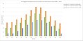 The average monthly air temperature recorded at the Townsend Creek Snotel site from 1989 to 2016
 -
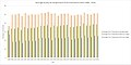 The average yearly air temperature recorded from the Townsend Creek Snotel Site from 1989 to 2016
 -
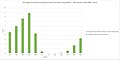 The average monthly precipitation and snow water equivalent recorded at Townsend Creek Snotel Site from 1980 to 2016
 -
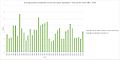 The average yearly precipitation and snow water equivalent recorded at the Townsend Creek Snotel site from 1980 to 2016


Images[edit]
-
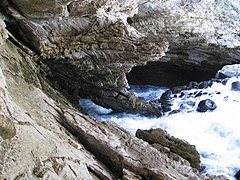 The Sinks
 -
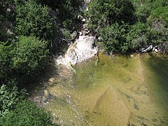 The Rise
 -
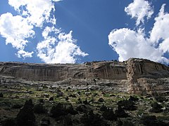 Canyon walls
 -
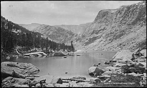 Source of the Popo Agie


References[edit]
- ^ a b "Sinks Canyon". Geographic Names Information System. United States Geological Survey, United States Department of the Interior.
- ^ "Table 1. Facilities managed by Wyoming State Parks, Historic Sites and Trails" (PDF). SOAR 2021. Wyoming Department of State Parks and Cultural Resources. p. 12. Retrieved September 5, 2017.
- ^ a b "Sinks Canyon State Park". Wyoming State Parks, Historic Sites & Trails. State of Wyoming. Retrieved September 5, 2017.
- ^ a b c d "Sinks Canyon State Park History". Wyoming State Parks, Historic Sites & Trails. State of Wyoming. Retrieved February 27, 2017.
- ^ a b c Woods, Lawrence (2013). Asmus Boysen and His Dam Problems. Bloomington, In.: AuthorHouse. p. 125. ISBN 978-1-4817-0672-8. Retrieved February 27, 2017.
- ^ a b c d e f Ebert, F.C. (1921). Records of water Levels in Wells in Southern California. Government Printing Office. p. 71. Retrieved February 27, 2017.
- ^ a b c Mavris; et al. (October 2015). "Decoding potential effects of climate and vegetation change on mineral weathering in alpine soils: An experimental study in the Wind River Range (Wyoming, USA)" (PDF). Geoderma. 255–256: 14. doi:10.1016/j.geoderma.2015.04.014.
- ^ a b "Sinks Canyon State Park Brochure" (PDF). Wyoming Department of State Parks and Cultural Resources. Retrieved March 23, 2020.
- ^ Richards, Derek (January 2014). "Climate analysis using tree-rings from the Wind River Range, Wyoming". UNI Scholar Works: 14. Retrieved February 27, 2017.
- ^ "Sinks Canyon State Park Animals". Wyoming State Parks, Historic Sites & Trails. State of Wyoming. Retrieved February 27, 2017.
- ^ "Sinks Canyon State Park Birds". Wyoming State Parks, Historic Sites & Trails. State of Wyoming. Retrieved February 27, 2017.
- ^ a b "State Use - Planning Documents". Wyoming State Parks, Historic Sites & Trails. State of Wyoming. Retrieved July 20, 2021.
- ^ a b c Klingsporn, Katie (July 20, 2021). "Falcons, a via ferrata and the clash of recreation v. conservation". Lander, Wy. Retrieved July 20, 2021.
- ^ "Sinks Canyon". Bureau of Land Management. Bureau of Land Management. Retrieved July 20, 2021.
- ^ "xmACIS2". National Oceanic and Atmospheric Administration. Retrieved December 5, 2023.
- ^ "Townsend Creek, Wyoming 1991-2020 Monthly Normals". Retrieved December 5, 2023.
External links[edit]
- Sinks Canyon State Park Wyoming State Parks, Historic Sites & Trails
- Sinks Canyon State Park Brochure and Map Wyoming State Parks, Historic Sites & Trails