
 French
 Deutsch
The Needles (Olympic Mountains)
| The Needles | |
|---|---|
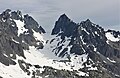
 The Needles seen from Mt. Deception | |
| Highest point | |
| Peak | Mount Johnson |
| Elevation | 7,680 ft (2,340 m)[1] |
| Coordinates | 47°49′57″N 123°14′14″W / 47.8326263°N 123.2372141°W[2] |
| Dimensions | |
| Length | 2 mi (3.2 km) North-South |
| Width | 1 mi (1.6 km) East-West |
| Geography | |
 The Needles Location in Washington  The Needles The Needles (the United States) | |
| Location | Olympic National Park Jefferson County, Washington |
| Country | United States |
| State | Washington |
| Range coordinates | 47°53′21″N 123°38′43″W / 47.8892984°N 123.6452825°W |
| Parent range | Olympic Mountains |
| Topo map | USGS Mount Deception |
| Geology | |
| Age of rock | Eocene |
The Needles is a mountain ridge located within Olympic National Park in Jefferson County of Washington state.[2]
Description[edit]
The peaks and pinnacles of The Needles are part of the Olympic Mountains and are situated within the Daniel J. Evans Wilderness. They are bounded by Mount Deception to the south and Gray Wolf Ridge to the north. Precipitation runoff from the ridge drains east into Royal Creek, and west into Gray Wolf River, which are both within the Dungeness River drainage basin. Old-growth forests of Douglas fir, western hemlock, and western redcedar grow on the lower slopes surrounding the peaks.
History[edit]
This geographical feature's descriptive name has been officially adopted by the U.S. Board on Geographic Names.[2] The 1889–90 Seattle Press Expedition originally named it the "Holmes Range".[3] The expedition, led by James Halbold Christie and Charles Adams Barnes, had also christened Mount Deception as "Mount Holmes", in honor of John H. Holmes of the Boston Herald.
Climate[edit]
Based on the Köppen climate classification, the Needles range is located in the marine west coast climate zone of western North America.[4] Most weather fronts originate in the Pacific Ocean, and travel east toward the Olympic Peninsula. As fronts approach, they are forced upward by the peaks, causing moisture to drop in the form of rain or snowfall (Orographic lift). As a result, the range experiences high precipitation, especially during the winter months. During winter months, weather is usually cloudy, but due to high pressure systems over the Pacific Ocean that intensify during summer months, there is often little or no cloud cover during the summer. The months July through September offer the most favorable weather for visiting The Needles.
Summits[edit]
Principal summits of The Needles:[5]
| Name | Elevation | Prominence | First ascent | Reference |
|---|---|---|---|---|
| Mount Johnson | 7,680 ft | 480 ft | 1940 | [1] |
| Martin Peak | 7,638 ft | 238 ft | 1940 | [6] |
| Devil's Fang | 7,600 ft | unknown | 1972 | [7] |
| Sweat Spire | 7,560 ft | unknown | 1962 | [8] |
| Mount Clark | 7,528 ft | 608 ft | 1940 | [9] |
| Gasp Pinnacle | 7,520 ft | 40 ft | 1958 | [10] |
| The Incisor | 7,440 ft | 40 ft | 1958 | [11] |
| Mount Walkinshaw | 7,378 ft | 378 ft | 1961 | [12] |
| Adelaide Peak | 7,300 ft | 120 ft | 1944 | [13] |
| Sundial | 7,200 ft | 80 ft | 1944 | [14] |
| The Arrowhead | 7,160 ft | unknown | 1962 | [15] |
Gallery[edit]
-
 The Needles seen from Obstruction Peak
 -
 Johnson, Sweat Spire, Gasp Pinnacle to left. Clark and Sundial to right.
 -
 Martin, Incisor, Johnson, Clark, and Sundial seen from Marmot Pass
 -
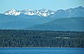 Mt. Deception (left), The Needles centered, Tyler Peak along right edge,
as seen from near Port Townsend


Geology[edit]
The Olympic Mountains are composed of obducted clastic wedge material and oceanic crust, primarily Eocene sandstone, turbidite, and basaltic oceanic crust.[16] The mountains were sculpted during the Pleistocene era by erosion and glaciers advancing and retreating multiple times.
See also[edit]
References[edit]
- ^ a b "Mount Johnson, Washington". Peakbagger.com. Retrieved 2022-02-14.
- ^ a b c "The Needles". Geographic Names Information System. United States Geological Survey, United States Department of the Interior. Retrieved 2022-02-14.
- ^ Parratt, Smitty (1984). Gods and Goblins: A Field Guide to Place Names of Olympic National Park (1st ed.).
- ^ Peel, M. C.; Finlayson, B. L.; McMahon, T. A. (2007). "Updated world map of the Köppen−Geiger climate classification". Hydrol. Earth Syst. Sci. 11 (5): 1633–1644. Bibcode:2007HESS...11.1633P. doi:10.5194/hess-11-1633-2007. ISSN 1027-5606.
- ^ "The Needles Area – Climbers Guide to the Olympic Mountains". climbersguideolympics.com. Archived from the original on 2017-03-21. Retrieved 2022-02-14.
- ^ "Martin Peak". Peakbagger.com. Retrieved 2022-02-14.
- ^ "Devil's Fang – Climbers Guide to the Olympic Mountains". climbersguideolympics.com. Archived from the original on 2010-11-27. Retrieved 2022-02-14.
- ^ "Sweat Spire, Washington". Peakbagger.com. Retrieved 2022-02-14.
- ^ "Mount Clark, Washington". Peakbagger.com. Retrieved 2022-02-14.
- ^ "Gasp Pinnacle, Washington". Peakbagger.com. Retrieved 2022-02-14.
- ^ "The Incisor, Washington". Peakbagger.com. Retrieved 2022-02-14.
- ^ "Mount Walkinshaw, Washington". Peakbagger.com. Retrieved 2022-02-14.
- ^ "Adelaide Peak, Washington". Peakbagger.com. Retrieved 2022-02-14.
- ^ "Sundial, Washington". Peakbagger.com. Retrieved 2022-02-14.
- ^ "The Arrowhead, Washington". Peakbagger.com. Retrieved 2022-02-14.
- ^ Alt, D.D.; Hyndman, D.W. (1984). Roadside Geology of Washington. pp. 249–259. ISBN 0-87842-160-2.
External links[edit]
- The Needles photo: Flickr
- "Olympic National Park". National Park Service. Archived from the original on 2022-03-14.
- Weather forecast: Mountain Forecast
![]() Media related to The Needles (Olympic Mountains) at Wikimedia Commons
Media related to The Needles (Olympic Mountains) at Wikimedia Commons