
 French
 Deutsch
Ute Mountain (New Mexico)
| Ute Mountain | |
|---|---|
.jpg) South aspect | |
| Highest point | |
| Elevation | 10,093 ft (3,076 m)[1][2] |
| Prominence | 2,483 ft (757 m)[3] |
| Isolation | 10.75 mi (17.30 km)[4] |
| Listing | Highest major summits of the US |
| Coordinates | 36°56′15″N 105°41′02″W / 36.9375203°N 105.6839005°W[5] |
| Naming | |
| Etymology | Ute[6] |
| Geography | |
 Ute Mountain Location in New Mexico  Ute Mountain Ute Mountain (the United States) | |
| Location | Rio Grande del Norte National Monument |
| Country | United States of America |
| State | New Mexico |
| County | Taos |
| Parent range | Sangre de Cristo Mountains Rocky Mountains |
| Topo map | USGS Ute Mountain |
| Geology | |
| Age of rock | 3.9 Million years[7] |
| Mountain type | volcanic cone |
| Type of rock | Dacite[7] |
| Volcanic arc | Taos Plateau volcanic field |
| Climbing | |
| Easiest route | class 2 hiking[4] |
Ute Mountain is a 10,093-foot elevation (3,076 m) summit located in Taos County, New Mexico, United States.
Description[edit]
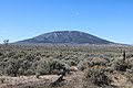
Ute Mountain is part of the Taos Mountains which are a subset of the Sangre de Cristo Mountains.[3] The isolated landmark is the highest point of the Cerro del Yuta Wilderness and Rio Grande del Norte National Monument which is administered by the Bureau of Land Management.[4] The remote mountain is situated 35 miles north of the town of Taos and four miles south of the New Mexico–Colorado border. Ute Mountain is a free-standing, dacitic, extinct Pliocene volcanic cone set within the Taos Plateau volcanic field.[8] Ute Mountain has a base diameter of five miles and topographic relief is significant as the summit rises 2,500 feet (760 meters) above the surrounding sagebrush-covered basalt plains.[2] The slopes of the mountain are covered with stands of pinyon pine, ponderosa pine, aspen and Douglas fir.[9] Precipitation runoff from the mountain drains to the Rio Grande which flows through a gorge along the western base of the mountain.
Etymology[edit]
The mountain is also known in Spanish as "Cerro del Yuta" (Mountain of the Ute).[10] The origin of the word Ute is unknown; it is first attested as Yuta in Spanish documents. The mountain is named after the Ute people whose self-designation is Núuchi-u, meaning 'the people'.[11] The state of Utah is also named after the Ute people. This landform's toponym has been officially adopted by the United States Board on Geographic Names,[5] and has appeared in publications since at least 1875.[12]
Gallery[edit]
-
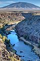 Ute Mountain and Rio Grande
 -
 Northeast aspect from Jaroso, Colorado
 -

-
 East aspect from Costilla, New Mexico


.jpg)

See also[edit]
References[edit]
- ^ United States Geological Survey topographical map - Ute Mountain
- ^ a b Robert Julyan (2006), The Mountains of New Mexico, University of New Mexico Press, ISBN 9780826335166, p. 66
- ^ a b "Ute Mountain, New Mexico". Peakbagger.com. Retrieved 2022-10-14.
- ^ a b c "Ute Mountain - 10,093' NM". listsofjohn.com. Retrieved 2022-10-14.
- ^ a b "Ute Mountain". Geographic Names Information System. United States Geological Survey, United States Department of the Interior. Retrieved 2022-10-14.
- ^ Robert Julyan (1996), The Place Names of New Mexico, University of New Mexico Press, ISBN 9780826351142, p. 367
- ^ a b Matthew L. Morgan, Stephen M. Keller, (2016), Unfolding the Geology of the West, Geological Society of America, p. 312
- ^ Lawrence H. Tanner, Sonia Calvari (2012), Volcanoes: Windows on the Earth, New Mexico Museum of Natural History and Science, ISBN 9780615663500, p. 161
- ^ Mark D. Williams, Amy Becker Williams (2018), 50 Things to See and Do in Northern New Mexico's Enchanted Circle, West Margin Press, ISBN 9781513261287
- ^ Federal Register, Volume 78, Issue 60, (2013), p. 18784
- ^ Givón, Talmy (January 1, 2011). Ute Reference Grammar. John Benjamins Publishing. pp. 1–3. ISBN 978-90-272-0284-0.
- ^ George M. Wheeler (1875), Annual Report Upon the Geographical Explorations and Surveys West of the One Hundredth Meridian, Washington: Government Printing Office, p. 100
External links[edit]
- Ute Mountain: weather forecast