
 French
 Deutsch
West Butte (Montana)
| West Butte | |
|---|---|
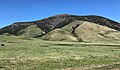
 Southeast aspect | |
| Highest point | |
| Elevation | 6,983 ft (2,128 m)[1][2] |
| Prominence | 3,638 ft (1,109 m)[2] |
| Parent peak | Kupunkamint Mountain (8,802 ft)[2] |
| Isolation | 81.27 mi (130.79 km)[2] |
| Listing | Most Isolated Summits in US |
| Coordinates | 48°55′54″N 111°32′01″W / 48.9316761°N 111.5336004°W[3] |
| Geography | |
 West Butte Location in Montana  West Butte Location in the United States | |
| Country | United States |
| State | Montana |
| County | Toole |
| Parent range | Sweet Grass Hills[1] |
| Topo map | USGS West Butte |
| Geology | |
| Age of rock | Eocene |
| Mountain type | Laccolith |
| Type of rock | Igneous rock |
| Climbing | |
| Easiest route | class 2 |
West Butte is a 6,983-foot-elevation (2,128-meter) mountain summit located in Toole County, Montana, United States.
Description[edit]
West Butte is the highest peak in the Sweet Grass Hills and the highest in the county.[1][2] It is situated 34 miles (55 km) north-northeast of Shelby, Montana, and four miles (6.4 km) south of the Canada–United States border, on land administered by the Bureau of Land Management.[4] Precipitation runoff from the mountain drains south to the Marias River and north to the Milk River.[1] Topographic relief is significant as the summit rises 3,000 feet (910 meters) above the surrounding plains in 2.5 miles (4.0 km) which makes it a prominent landmark visible for many miles.
Geology[edit]
West Butte is an exposed laccolith composed of diorite porphyry and monzonite which was created by an igneous intrusion through older Mississippian sedimentary rocks during the Eocene, about 50 million years ago.[4][5] These sedimentary rocks are primarily limestone and shale. Over time, erosion of the sedimentary rock has exposed the solidified laccolith which is more resistant to weathering.
History[edit]
The Sweet Grass Hills, which are centered in buffalo hunting territory, are sacred to the Blackfoot and other tribes.[6] The Blackfoot called West Butte "ami sítse katúyis" which means "west side sweet pine."[7] In 1806, Meriwether Lewis sighted West Butte from the Missouri River, which is 100 miles (160 km) distant, and George Mercer Dawson reported seeing it from 140 miles (230 km) away at Blackfoot Crossing in Alberta.[7] The landform's toponym has been officially adopted by the United States Board on Geographic Names.[3]
Climate[edit]
Based on the Köppen climate classification, West Butte is located in a semi-arid climate zone with long, cold, dry winters and hot summers with cool nights.[5][8] Winter temperatures can drop below −10 °F with wind chill factors below −30 °F. The wettest period of the year is generally May through August, with up to 20 inches of precipitation falling annually on the peak.[5]
West Butte peak has a dry winter subarctic climate (Köppen Dwc).
| Climate data for West Butte (MT) 48.9319 N, 111.5336 W, Elevation: 6,598 ft (2,011 m) (1991–2020 normals) | |||||||||||||
|---|---|---|---|---|---|---|---|---|---|---|---|---|---|
| Month | Jan | Feb | Mar | Apr | May | Jun | Jul | Aug | Sep | Oct | Nov | Dec | Year |
| Mean daily maximum °F (°C) | 28.7 (−1.8) | 29.1 (−1.6) | 34.0 (1.1) | 41.5 (5.3) | 50.9 (10.5) | 58.7 (14.8) | 69.1 (20.6) | 69.5 (20.8) | 60.0 (15.6) | 46.4 (8.0) | 32.8 (0.4) | 27.6 (−2.4) | 45.7 (7.6) |
| Daily mean °F (°C) | 21.9 (−5.6) | 20.9 (−6.2) | 24.8 (−4.0) | 31.1 (−0.5) | 40.2 (4.6) | 47.4 (8.6) | 56.5 (13.6) | 56.7 (13.7) | 48.1 (8.9) | 36.6 (2.6) | 26.4 (−3.1) | 21.2 (−6.0) | 36.0 (2.2) |
| Mean daily minimum °F (°C) | 15.0 (−9.4) | 12.7 (−10.7) | 15.6 (−9.1) | 20.8 (−6.2) | 29.4 (−1.4) | 36.2 (2.3) | 44.0 (6.7) | 44.0 (6.7) | 36.2 (2.3) | 26.8 (−2.9) | 20.0 (−6.7) | 14.8 (−9.6) | 26.3 (−3.2) |
| Average precipitation inches (mm) | 0.73 (19) | 0.68 (17) | 1.04 (26) | 1.75 (44) | 2.77 (70) | 6.07 (154) | 2.40 (61) | 2.47 (63) | 2.22 (56) | 1.77 (45) | 0.96 (24) | 0.70 (18) | 23.56 (597) |
| Source: PRISM Climate Group[9] | |||||||||||||
See also[edit]
- Gold Butte (Middle Butte)
- Mount Lebanon (East Butte)
 Mountains portal
Gallery[edit]
-
 Southwest aspect
 -
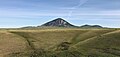 Southeast aspect
 -
 South aspect
 -
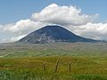
 West Butte
 -
 West Butte


References[edit]
- ^ a b c d "West Butte, Montana". Peakbagger.com. Retrieved 2023-07-24.
- ^ a b c d e "West Butte - 6,983' MT". listsofjohn.com. Retrieved 2023-07-24.
- ^ a b "West Butte". Geographic Names Information System. United States Geological Survey, United States Department of the Interior. Retrieved 2023-07-24.
- ^ a b Sweet Grass Hills, blm.gov, Retrieved 2023-07-24.
- ^ a b c Sweet Grass Hills Resource(s) Management Plan (RMP) Amendment and West HiLine Resource(s) Management Plan (RMP), Toole County, Liberty County: Environmental Impact Statement, 1996, p. 13, 19.
- ^ Rich Aarstad, Montana Place Names from Alzada to Zortman, Montana Historical Society, 2009, ISBN 9780975919613, p. 259.
- ^ a b William A Lovis, Robert Whallon (2016), Marking the Land, Routledge, ISBN 9781317361169, p. 48.
- ^ Peel, M. C.; Finlayson, B. L.; McMahon, T. A. (2007). "Updated world map of the Köppen−Geiger climate classification". Hydrol. Earth Syst. Sci. 11. ISSN 1027-5606.
- ^ "PRISM Climate Group, Oregon State University". PRISM Climate Group, Oregon State University. Retrieved October 2, 2023.
To find the table data on the PRISM website, start by clicking Coordinates (under Location); copy Latitude and Longitude figures from top of table; click Zoom to location; click Precipitation, Minimum temp, Mean temp, Maximum temp; click 30-year normals, 1991-2020; click 800m; click Retrieve Time Series button.
External links[edit]
- Weather forecast: West Butte