Xiangfang, Harbin
Xiangfang 香坊区 | |
|---|---|
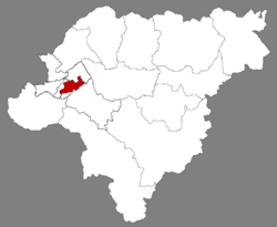
 Location of Xiangfang in Harbin | |
 Harbin in Heilongjiang | |
| Coordinates: 45°43′26″N 126°40′43″E / 45.7240°N 126.6786°E[1] | |
| Country | People's Republic of China |
| Province | Heilongjiang |
| Sub-provincial city | Harbin |
| Area | |
| • Total | 339.5 km2 (131.1 sq mi) |
| Population (2019)[3] | |
| • Total | 741,246 |
| • Density | 2,200/km2 (5,700/sq mi) |
| Time zone | UTC+8 (China Standard) |
| Website | hrbxf |
Xiangfang District (simplified Chinese: 香坊区; traditional Chinese: 香坊區; pinyin: Xiāngfāng Qū) is one of nine districts of the prefecture-level city of Harbin, the capital of Heilongjiang Province, Northeast China. It is an urban district in the pre-1940 part of Harbin, bordering the districts of Daowai to the north, Acheng to the southeast, Pingfang to the southwest, and Nangang to the west. It is an industrialized area, and contains the main scientific, technological and industrial zones of the city. The Harbin Development Zone is in the district.[4]
Administrative divisions[edit]
On 15 August 2006, Dongli District (动力区) was merged into Xiangfang District,[4] thus adding Chaoyang Town (朝阳镇).
The current subdistricts are:[5]
|
|
The current towns are:
|
Notes[edit]
- ^ Google (2014-07-02). "Xiangfang" (Map). Google Maps. Google. Retrieved 2014-07-02.
- ^ Harbin Statistical Yearbook 2011 (《哈尔滨统计年鉴2011》). Accessed 8 July 2014.
- ^ 全国各县市区人口排名 www.hongheiku.com (in Chinese). hongheiku. Retrieved 2022-01-05.
- ^ a b "Administrative Divisions". Harbin City Government. Archived from the original on 17 October 2012.
- ^ "国家统计局 2019" (in Chinese). National Bureau of Statistics of the People's Republic of China. Retrieved 2021-12-07.
External links[edit]
- "Xiangfang District Government site" (in Chinese). - Google translation


 French
 Deutsch