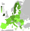
پرونده:Knowledge of English EU map.svg - ویکیپدیا، دانشنامهٔ آزاد

حجم پیشنمایش PNG این SVG file:۵۸۷ × ۶۰۰ پیکسل کیفیتهای دیگر: ۲۳۵ × ۲۴۰ پیکسل | ۴۷۰ × ۴۸۰ پیکسل | ۷۵۱ × ۷۶۸ پیکسل | ۱٬۰۰۲ × ۱٬۰۲۴ پیکسل | ۲٬۰۰۴ × ۲٬۰۴۸ پیکسل | ۵۹۰ × ۶۰۳ پیکسل.
پروندهٔ اصلی (پروندهٔ اسویجی، با ابعاد ۵۹۰ × ۶۰۳ پیکسل، اندازهٔ پرونده: ۶۷۱ کیلوبایت)
تاریخچهٔ پرونده
روی تاریخ/زمانها کلیک کنید تا نسخهٔ مربوط به آن هنگام را ببینید.
| تاریخ/زمان | بندانگشتی | ابعاد | کاربر | توضیح | |
|---|---|---|---|---|---|
| کنونی | ۳ فوریهٔ ۲۰۲۰، ساعت ۱۰:۳۶ |  | ۵۹۰ در ۶۰۳ (۶۷۱ کیلوبایت) | Darranc | Update since UK left the EU |
| ۱۵ فوریهٔ ۲۰۱۵، ساعت ۲۳:۳۰ |  | ۵۹۰ در ۶۰۳ (۶۷۱ کیلوبایت) | Leftcry | Update layout and information | |
| ۱۷ اکتبر ۲۰۱۱، ساعت ۱۱:۴۹ |  | ۱٬۲۱۲ در ۱٬۲۴۲ (۵۵۲ کیلوبایت) | Treehill | deletion of Turkey, I let only candidate country with an accession date planned (Croatia and Iceland). | |
| ۷ سپتامبر ۲۰۱۱، ساعت ۰۶:۳۴ |  | ۱٬۲۱۲ در ۱٬۲۴۲ (۵۵۲ کیلوبایت) | Treehill | (norway was not deleted before, maybe an error) | |
| ۶ سپتامبر ۲۰۱۱، ساعت ۲۰:۵۸ |  | ۱٬۲۱۲ در ۱٬۲۴۲ (۵۵۲ کیلوبایت) | Treehill | deletion of Norway, as explained previously. Not an EU country (note that the name of the file is "Knowledge_of_English_EU_map.svg"). | |
| ۶ سپتامبر ۲۰۱۱، ساعت ۱۹:۵۰ |  | ۱٬۲۱۲ در ۱٬۲۴۲ (۵۵۲ کیلوبایت) | Treehill | I deleted Switzerland which is neither in the EU nor a candidate country. | |
| ۱۲ ژوئیهٔ ۲۰۱۱، ساعت ۱۱:۱۲ |  | ۱٬۲۱۲ در ۱٬۲۴۲ (۵۵۲ کیلوبایت) | J intela | Added Norway and Switzerland http://en.wikipedia.org/wiki/List_of_countries_by_English-speaking_population | |
| ۸ آوریل ۲۰۱۱، ساعت ۱۹:۰۸ |  | ۱٬۲۱۲ در ۱٬۲۴۲ (۵۵۲ کیلوبایت) | Alphathon | Improved British Isles | |
| ۲۷ اوت ۲۰۱۰، ساعت ۱۷:۴۲ |  | ۱٬۲۱۲ در ۱٬۲۴۲ (۵۲۰ کیلوبایت) | Alphathon | {{Information |Description={{en|1=Knowledge of English language in EU}} |Source=*File:Knowledge_of_German_EU_map.png *File:Knowledge_English_EU_map.png |Date=2010-08-27 17:41 (UTC) |Author=*File:Knowledge_of_German_EU_map.png: [[User:Her |
کاربرد پرونده
صفحههای زیر از این تصویر استفاده میکنند:
کاربرد سراسری پرونده
ویکیهای دیگر زیر از این پرونده استفاده میکنند:
- کاربرد در ar.wikipedia.org
- کاربرد در ast.wikipedia.org
- کاربرد در azb.wikipedia.org
- کاربرد در be.wikipedia.org
- کاربرد در ca.wikipedia.org
- کاربرد در de.wikipedia.org
- کاربرد در el.wikipedia.org
- کاربرد در en.wikipedia.org
- کاربرد در eo.wikipedia.org
- کاربرد در es.wikipedia.org
- کاربرد در et.wikipedia.org
- کاربرد در fi.wikipedia.org
- کاربرد در fr.wikipedia.org
- کاربرد در he.wikipedia.org
- کاربرد در hu.wikipedia.org
- کاربرد در id.wikipedia.org
- کاربرد در it.wikipedia.org
- کاربرد در ja.wikipedia.org
- کاربرد در kk.wikipedia.org
- کاربرد در lez.wikipedia.org
- کاربرد در nl.wikipedia.org
- کاربرد در pl.wikipedia.org
- کاربرد در pl.wiktionary.org
- کاربرد در roa-tara.wikipedia.org
- کاربرد در ro.wikipedia.org
- کاربرد در ru.wikipedia.org
- کاربرد در sr.wikipedia.org
- کاربرد در sv.wikipedia.org
- کاربرد در tr.wikipedia.org
- کاربرد در ug.wikipedia.org
- کاربرد در uk.wikipedia.org
- کاربرد در ur.wikipedia.org
- کاربرد در vi.wikipedia.org
- کاربرد در zh.wikipedia.org


 French
 Deutsch
