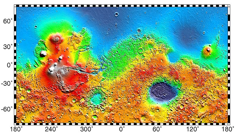
ファイル:Mars Map.JPG

このプレビューのサイズ: 800 × 457 ピクセル。 その他の解像度: 320 × 183 ピクセル | 640 × 365 ピクセル | 1,024 × 584 ピクセル | 1,280 × 730 ピクセル | 2,180 × 1,244 ピクセル。
元のファイル (2,180 × 1,244 ピクセル、ファイルサイズ: 2.33メガバイト、MIME タイプ: image/jpeg)
ファイルの履歴
過去の版のファイルを表示するには、その版の日時をクリックしてください。
| 日付と時刻 | サムネイル | 寸法 | 利用者 | コメント | |
|---|---|---|---|---|---|
| 現在の版 | 2019年5月4日 (土) 02:57 |  | 2,180 × 1,244 (2.33メガバイト) | Huntster | Full resolution from NASA/JPL. |
| 2014年5月6日 (火) 09:23 |  | 613 × 350 (139キロバイト) | Wikiuser13 | Transferred from en.wikipedia |
ファイルの使用状況
以下の 47 ページがこのファイルを使用しています:
- アウストラレ高原
- アキダリア平原
- アマゾニス平原
- アルカディア平原
- アルバ・パテラ
- インサイト (探査機)
- エリシウム山
- エリシウム平原
- オクティヴィア・E・バトラー・ランディング
- オポチュニティ
- オリンポス山 (火星)
- カール・セーガン
- グリーンバレー (火星)
- ゲール (クレーター)
- スピリット (探査機)
- タルシス
- タルシス三山
- ディープ・スペース2号
- トーマス・マッチ
- バイキング1号
- バイキング2号
- バイキング計画
- パーサヴィアランス
- フェニックス (探査機)
- ブラッドベリ・ランディング
- ヘラス平原
- マリネリス峡谷
- マルス2号
- マルス3号
- マーズ2020
- マーズ・エクスプロレーション・ローバー
- マーズ・サイエンス・ラボラトリー
- マーズ・パスファインダー
- マーズ・ポーラー・ランダー
- マーズ・ローバー
- ユリシーズ・トーラス
- ユートピア平原
- 地球外の記念碑のリスト
- 火星
- 火星にある人工物の一覧
- 火星の人面岩
- 火星の植民
- 火星探査
- 祝融号
- Template:火星の特徴と人工物
- Template:火星の特徴と記念碑
- Template:火星地図
グローバルなファイル使用状況
以下に挙げる他のウィキがこの画像を使っています:
- ar.wikipedia.org での使用状況
- az.wikipedia.org での使用状況
- be.wikipedia.org での使用状況
- bn.wikipedia.org での使用状況
- bs.wikipedia.org での使用状況
- ca.wikipedia.org での使用状況
- Opportunity
- Escala de temps geològics de Mart
- Mars Pathfinder
- Programa Viking
- Mars rover
- Phoenix (sonda)
- Spirit
- Viking 1
- Geografia de Mart
- Viking 2
- Beagle 2
- Aigua a Mart
- Astromòbil
- Mòdul de descens
- Curiosity
- Objectes artificials a la superfície de Mart
- Mars Polar Lander
- Mars 6
- Mars 3
- Usuari:Mcapdevila/Exploració de Mart
- Deep Space 2
- Rosalind Franklin (astromòbil)
- Exploració de Mart
このファイルのグローバル使用状況を表示する。


 French
 Deutsch
