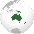
ファイル:Oceania (orthographic projection).svg

この SVG ファイルのこの PNG プレビューのサイズ: 541 × 541 ピクセル. その他の解像度: 240 × 240 ピクセル | 480 × 480 ピクセル | 768 × 768 ピクセル | 1,024 × 1,024 ピクセル | 2,048 × 2,048 ピクセル。
元のファイル (SVG ファイル、541 × 541 ピクセル、ファイルサイズ: 63キロバイト)
ファイルの履歴
過去の版のファイルを表示するには、その版の日時をクリックしてください。
| 日付と時刻 | サムネイル | 寸法 | 利用者 | コメント | |
|---|---|---|---|---|---|
| 現在の版 | 2023年2月6日 (月) 18:54 |  | 541 × 541 (63キロバイト) | Golden Mage | A change to the map of Asia will first face debate from others. Hence, a change to the commonly accepted map of Oceania cannot be made without a wider consensus. |
| 2023年2月6日 (月) 06:33 |  | 541 × 541 (108キロバイト) | Kwamikagami | rv: then perhaps we need to change the Asia map to match. This is as defined in WP. | |
| 2023年2月5日 (日) 18:19 |  | 541 × 541 (63キロバイト) | Golden Mage | Reverted to the map that displays the more accepted definition of Oceania's boundaries. Widely accepted geopolitical definitions take precedence over mere geographical ones. The map of the Wikipedia page for Asia already includes the Maluku Islands. | |
| 2023年2月5日 (日) 05:01 |  | 541 × 541 (108キロバイト) | Treetoes023 | Reverted to version as of 06:27, 24 December 2022 (UTC) | |
| 2023年2月5日 (日) 05:00 |  | 541 × 541 (63キロバイト) | Treetoes023 | Reverted to version as of 13:25, 31 December 2022 (UTC) | |
| 2023年2月5日 (日) 04:55 |  | 541 × 541 (108キロバイト) | Treetoes023 | Reverted to version as of 00:31, 4 December 2022 (UTC) | |
| 2022年12月31日 (土) 13:25 |  | 541 × 541 (63キロバイト) | Golden Mage | Reverted to the map that displays the more accepted definition of Oceania's boundaries. Widely accepted geopolitical definitions take precedence over mere geographical ones. | |
| 2022年12月24日 (土) 06:27 |  | 541 × 541 (108キロバイト) | Kwamikagami | Reverted to version as of 00:31, 4 December 2022 (UTC) definition per WP-en | |
| 2022年12月22日 (木) 06:13 |  | 541 × 541 (63キロバイト) | Golden Mage | Reverted to the map that displays the more accepted definition of Oceania's boundaries. | |
| 2022年12月4日 (日) 00:31 |  | 541 × 541 (108キロバイト) | Kwamikagami | the Weber line divides Oceanic from Asian Wallacea |
ファイルの使用状況
このファイルへは 100 を超える数のページで使用されています。 以下の一覧ではこのファイルを使用している最初の 100 ページのみを表示しています。 完全な一覧も参照してください。
- 1950年代
- 1960年代
- 1970年代
- 1972年
- 1980年代
- 1982年
- 1984年
- 1988年
- 1989年
- 1990年代
- 1993年
- 1994年
- 1996年
- 1999年
- 2000年
- 2000年代
- 2001年
- 2002年
- 2003年
- 2009年
- 2010年代
- 2011年
- 2012年
- 2013年
- 2014年
- 2015年
- 2016年
- 2017年
- 2018年
- アジア大陸
- アフリカ
- アフリカ大陸
- アフロ・ユーラシア大陸
- アメイジア大陸
- アメリカ大陸
- アメリカ州
- アメリカ領サモア
- インドネシア
- インド洋
- ウェーク島
- ウォリス・フツナ
- オセアニア
- カアフマヌ
- キリバス
- キングマン・リーフ
- グアム
- ゴンドワナ大陸
- サモア
- ジャーヴィス島
- ジョンストン島
- ソロモン諸島
- チリ
- トンガ
- ナウル
- ニウエ
- ニューカレドニア
- ニュージーランド
- ヌーナ大陸
- ハウランド島
- ハワイ州
- バヌアツ
- パノティア大陸
- パプアニューギニア
- パルミラ環礁
- フィジー
- ベーカー島
- ポリネシア
- マグリブ
- マーシャル諸島
- ミクロネシア
- ミクロネシア連邦
- メラネシア
- ヨーロッパ
- ヨーロッパ大陸
- ロディニア大陸
- ローラシア大陸
- 伝説上の大陸
- 北アメリカ
- 北アメリカ大陸
- 北マリアナ諸島
- 北半球
- 北極
- 北極圏
- 北極海
- 南アメリカ
- 南アメリカ大陸
- 南半球
- 南極
- 南極大陸
- 南極海
- 南鳥島
- 国の一覧 (大陸別)
- 大洋
- 大西洋
- 大陸
- 太平洋
- 火山列島
- 赤道
- 陸半球
- 利用者:Kahusi/ねた帖
このファイルへのリンク元を更にを表示する。
グローバルなファイル使用状況
以下に挙げる他のウィキがこの画像を使っています:
- ab.wikipedia.org での使用状況
- ady.wikipedia.org での使用状況
- af.wikipedia.org での使用状況
- Afrika
- Asië
- Europa
- Kiribati
- Noord-Amerika
- Suid-Amerika
- Vanuatu
- Guam
- Nieu-Seeland
- Sjabloon:Kontinente
- Australië
- Nauru
- Wellington, Nieu-Seeland
- Hoofstad
- Lys van hoofstede
- Sjabloon:Lande van Oseanië
- Honolulu
- Antarktika
- Gondwana
- Eurasië
- Laurasië
- Kategorie:Lande in Oseanië
- Lys van lande
- Fidji
- Canberra
- Hawaii
- Lys van nasionale leuses
- Clipperton
- Oseanië
- Norfolkeiland
- Amerikas
- Tonga
- Tuvalu
- Sjabloon:Hoofstede in Oseanië
- Palau
- Australië (kontinent)
- Afrika-Eurasië
- Samoa
- Marshalleilande
- Salomonseilande
- Papoea-Nieu-Guinee
- Gefedereerde State van Mikronesië
- Nukuʻalofa
- Port Moresby
- Apia
- Funafuti
- Honiara
- Majuro
このファイルのグローバル使用状況を表示する。


 French
 Deutsch