
 French
 Deutsch
Файл:SAR Kilauea topo interferogram.jpg — Википедия
SAR_Kilauea_topo_interferogram.jpg (577 × 577 пкс, размер файла: 152 Кб, MIME-тип: image/jpeg)
Этот файл находится на Викискладе. Сведения о нём показаны ниже. Викисклад — централизованное хранилище для свободных файлов, используемых в проектах Викимедиа. |
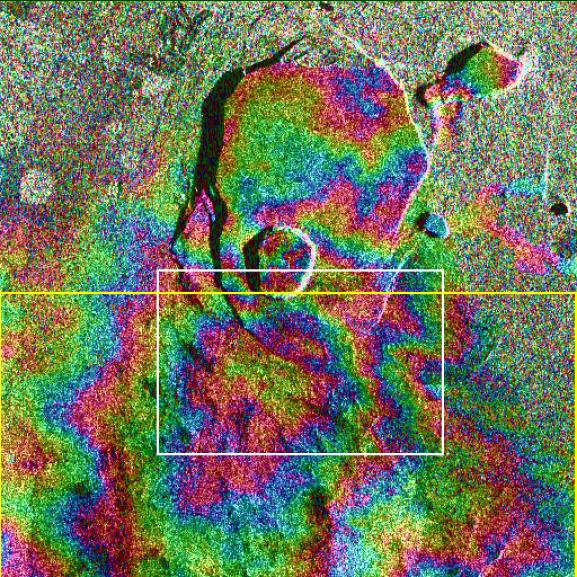
| Описание | PIA01763: Space Radar Image of Kilauea, Hawaii - interferometry 1 |
| Дата | |
| Источник | http://photojournal.jpl.nasa.gov/catalog/PIA01762 |
| Автор | JPL |
| Права (Повторное использование этого файла) | Courtesy NASA/JPL-Caltech, http://www.jpl.nasa.gov/images/policy/ |
| Этот файл находится в общественном достоянии (англ. public domain), так как он был создан NASA (Национальным управлением по аэронавтике и исследованию космического пространства). Политика авторского права NASA гласит, что «Материал NASA не защищается авторским правом, если не указано иное». (См. Template:PD-USGov, страницу политики авторского права NASA или политику использования изображений JPL.) | ||
 | Предупреждения:
|
Original Caption Released with Image: Data acquired on April 13, 1994 and on October 4, 1994 from the X-band Synthetic Aperture Radar on board the space shuttle Endeavour were used to generate interferometric fringes, which were overlaid on the X-SAR image of Kilauea. The volcano is centered in this image at 19.58 degrees north latitude and 155.55 degrees west longitude. The image covers about 9 kilometers by 13 kilometers (5.6 miles by 8 miles). The X-band fringes correspond clearly to the expected topographic image. The yellow line indicates the area below which was used for the three-dimensional image using altitude lines. The yellow rectangular frame fences the area for the final topographic image.
Spaceborne Imaging Radar-C and X-band Synthetic Aperture Radar (SIR-C/X-SAR) is part of NASA's Mission to Planet Earth. The radars illuminate Earth with microwaves, allowing detailed observations at any time, regardless of weather or sunlight conditions. SIR-C/X-SAR uses three microwave wavelengths: L-band (24 cm), C-band (6 cm) and X-band (3 cm). The multi-frequency data will be used by the international scientific community to better understand the global environment and how it is changing. The SIR-C/X-SAR data, complemented by aircraft and ground studies, will give scientists clearer insights into those environmental changes which are caused by nature and those changes which are induced by human activity.
SIR-C was developed by NASA's Jet Propulsion Laboratory. X-SAR was developed by the Dornier and Alenia Spazio companies for the German space agency, Deutsche Agentur fuer Raumfahrtangelegenheiten (DARA), and the Italian space agency, Agenzia Spaziale Italiana (ASI), with the Deutsche Forschungsanstalt fuer Luft und Raumfahrt e.V.(DLR), the major partner in science, operations and data processing of X-SAR. The Instituto Ricerca Elettromagnetismo Componenti Elettronici (IRECE) at the University of Naples was a partner in interferometry analysis.
| Аннотации | Это изображение аннотировано: Просмотреть аннотации на Викискладе |
История файла
Нажмите на дату/время, чтобы посмотреть файл, который был загружен в тот момент.
| Дата/время | Миниатюра | Размеры | Участник | Примечание | |
|---|---|---|---|---|---|
| текущий | 11:03, 30 марта 2007 | | 577 × 577 (152 Кб) | Eve Hall~commonswiki | {{Information |Description=PIA01763: Space Radar Image of Kilauea, Hawaii - interferometry 1 |Source=http://photojournal.jpl.nasa.gov/catalog/PIA01762 |Date=1999-05-01 |Author=JPL |Permission=Courtesy NASA/JPL-Caltech, http://www.jpl.nasa.gov/images/polic |
Использование файла
Следующая страница использует этот файл:
Глобальное использование файла
Данный файл используется в следующих вики:
- Использование в en.wikipedia.org
- Использование в en.wikiversity.org
- Использование в es.wikipedia.org
- Использование в uk.wikipedia.org