
 French
 Deutsch
Dosya:France départementale.svg - Vikipedi

Tam çözünürlük (SVG dosyası, sözde 2.000 × 1.898 piksel, dosya boyutu: 1,87 MB)
Bu dosya Wikimedia Commons'ta bulunmaktadır. Dosyanın açıklaması aşağıda gösterilmiştir. Commons, serbest/özgür telifli medya dosyalarının bulundurulduğu depodur. Siz de yardım edebilirsiniz. |
Özet
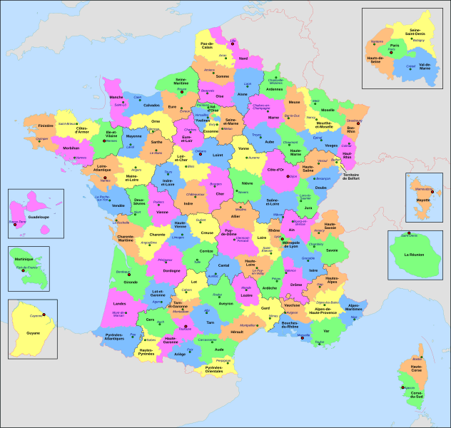
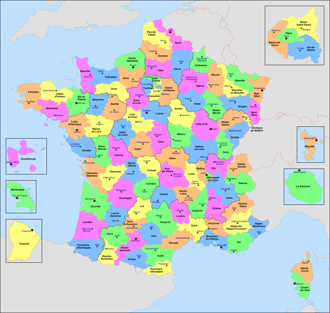
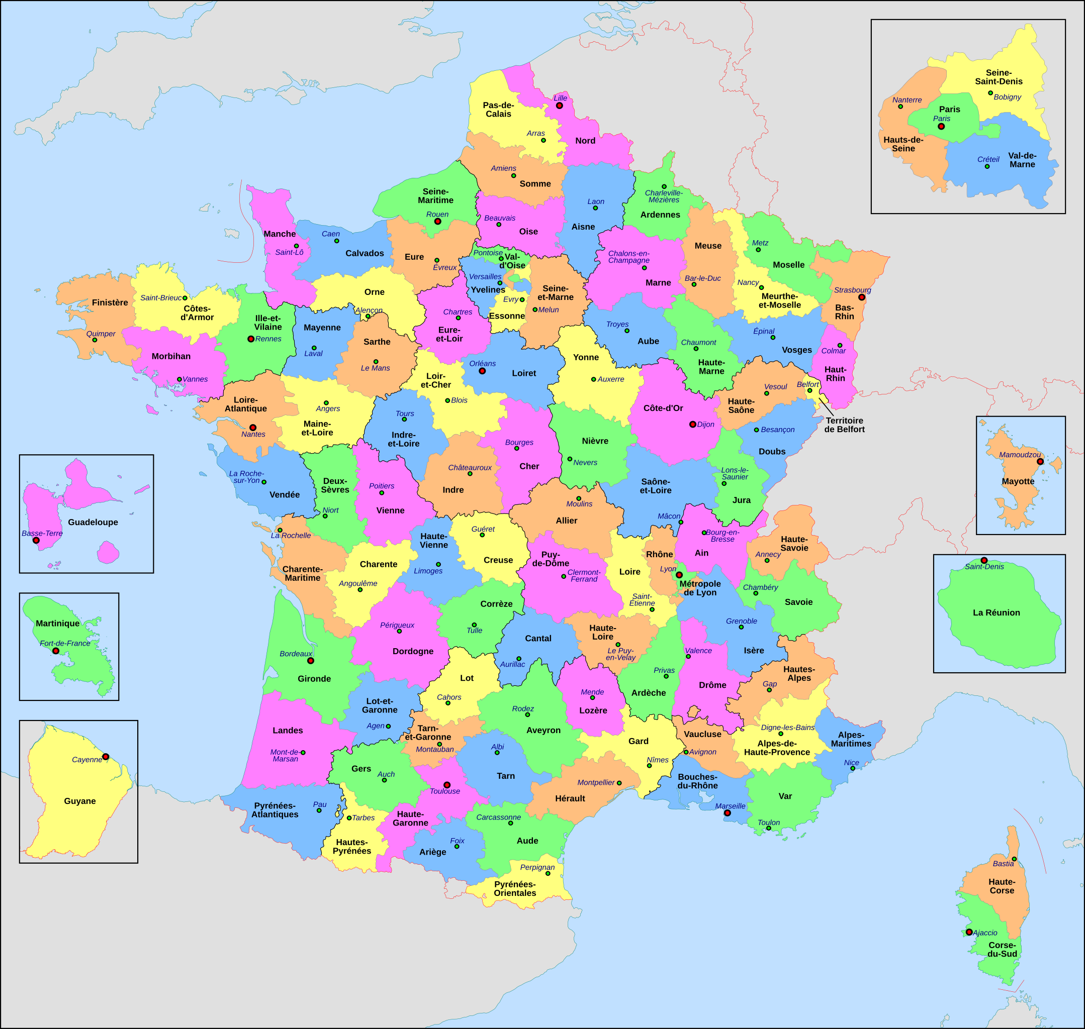
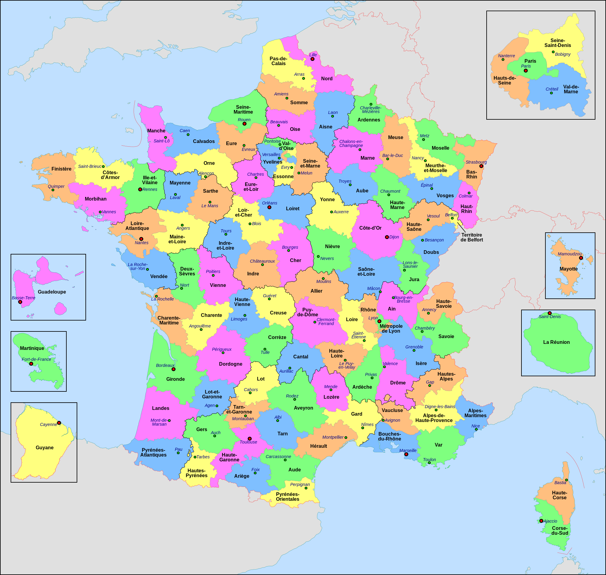
| Açıklama | Français : Carte administrative de la France, créée sous Inkscape 0.47 à partir de plusieurs cartes (notamment celle-ci) créées par Sting. Le fichier comporte vingt-quatre calques : Cadre, Chef-lieux de région, Villes, Chef-lieux de département, Numéros de département, Noms des régions, Nom des départements, **Encarts Départements d'Outre-Mer, **Encart Paris-Petite-Couronne, Coordonnées, Échelle et Mini-carte, Frontières internationales, Côtes, Limites régionales, Limites départementales, Lacs, Fleuves, *Régions métropolitaines, *Départements métropolitains, Terres françaises, Terres étrangères, Mers et océans, Échelle altimétrique, Topographie.
English: Administrative map of France, created under Inkscape 0.47 from several of the maps (especially this one) created by Sting. The file consists of twenty-four layers: Frame, Administrative Centres of Regions, Towns, Administrative Centres of Departments, Numbers of Departments, Names of Regions, Names of Departments, **Overseas Departements Insets, **Paris Conurbation Inset, Coordinates, Scale and Mini-map, International boundaries, Coasts, Regional boundaries, Departmental boundaries, Lakes, Rivers, *Metropolitan Regions, *Metropolitan Departments, French lands, Foreign lands, Seas and Oceans, Altimetric Scale, Topography.
|
| Tarih | |
| Kaynak | Yükleyenin kendi çalışması |
| Yazar | Nilstilar |
| Diğer sürümler |
|
| SVG gelişimi | Bu SVG kaynak kodu geçerlidir. Bu vektörel grafik Inkscape ile oluşturuldu. Bu SVG dosyası, gömülü metin editörü kullanarak kolayca çevirebilir. |


Lisanslama
- Şu seçeneklerde özgürsünüz:
- paylaşım – eser paylaşımı, dağıtımı ve iletimi
- içeriği değiştirip uyarlama – eser adaptasyonu
- Aşağıdaki koşullar geçerli olacaktır:
- atıf – Esere yazar veya lisans sahibi tarafından belirtilen (ancak sizi ya da eseri kullanımınızı desteklediklerini ileri sürmeyecek bir) şekilde atıfta bulunmalısınız.
- benzer paylaşım – Maddeyi yeniden karıştırır, dönüştürür veya inşa ederseniz, katkılarınızı orijinal olarak aynı veya uyumlu lisans altında dağıtmanız gerekir.
This image is used on a user page of a Wikimedia user and is stored on Commons according to the rules set out in Commons:Project scope#File in use on Commons only: the uploading of small numbers of images (e.g. of yourself) for use on a personal Commons user page is allowed or Commons:Project scope#File in use in another Wikimedia project: the uploading of small numbers of images (e.g. of yourself) for use on a personal user page of another project is allowed as long as that user is or was an active participant on that project.
If the image ceases to be used it may be eligible for deletion as it may have no educational purpose.
Dosya geçmişi
Dosyanın herhangi bir zamandaki hâli için ilgili tarih/saat kısmına tıklayın.
| Tarih/Saat | Küçük resim | Boyutlar | Kullanıcı | Yorum | |
|---|---|---|---|---|---|
| güncel | 20.29, 22 Haziran 2022 | | 2.000 × 1.898 (1,87 MB) | OpesMentis | Added hyphens on departments' names and towns' names and fixed "Réunion" to "La Réunion" |
| 18.10, 9 Kasım 2021 |  | 2.000 × 1.898 (1,87 MB) | Puck04 | fixed SVG code (was "W3C-invalid") + cleanup using text editor; contains some invisible pathes | |
| 00.40, 1 Mayıs 2020 |  | 2.000 × 1.898 (4,7 MB) | ChrisPtDe | File uploaded using svgtranslate tool (https://tools.wmflabs.org/svgtranslate/). Added translation for frp. | |
| 22.17, 28 Nisan 2020 |  | 2.000 × 1.898 (4,7 MB) | ChrisPtDe | File uploaded using svgtranslate tool (https://tools.wmflabs.org/svgtranslate/). Added translation for frp. | |
| 22.56, 25 Nisan 2020 |  | 2.000 × 1.898 (4,68 MB) | ChrisPtDe | File uploaded using svgtranslate tool (https://tools.wmflabs.org/svgtranslate/). Added translation for frp. | |
| 14.13, 4 Kasım 2018 |  | 2.000 × 1.898 (4,55 MB) | Nilstilar | Corse "réunifiée" pose problème | |
| 12.05, 4 Kasım 2018 |  | 2.000 × 1.898 (4,54 MB) | Nilstilar | Corse "réunifiée" (collectivité territoriale unique — département & région — au 1/1/2018) | |
| 13.01, 15 Ekim 2018 |  | 2.000 × 1.898 (4,55 MB) | Nilstilar | Reverted to version as of 18:52, 10 May 2017 (UTC) | |
| 22.30, 28 Aralık 2017 |  | 2.000 × 1.898 (2,24 MB) | Ras67 | frame removed, all invisible data stripped | |
| 18.52, 10 Mayıs 2017 |  | 2.000 × 1.898 (4,55 MB) | Nilstilar | Rétablissement des limites régionales (au 01/10/2016) |
Dosya kullanımı
Bu görüntü dosyasına bağlantısı olan sayfalar:
- Ardenler
- Denizaşırı il
- Fransa'daki 20.000'den fazla nüfusa sahip şehirler listesi
- Fransız Guyanası
- Fransız Güney ve Antarktika Toprakları
- Fransız Polinezyası
- Lyon Metropolü
- Mayotte
- Paris
- Réunion
- Saint-Martin Kolektivitesi
- Saint Barthélemy
- Wallis ve Futuna
- Yeni Kaledonya
- Şablon:Fransa'nın illeri
- Kategori:Fransa'nın illeri
Küresel dosya kullanımı
Aşağıdaki diğer vikiler bu dosyayı kullanır:
- ar.wikipedia.org üzerinde kullanımı
- arz.wikipedia.org üzerinde kullanımı
- ast.wikipedia.org üzerinde kullanımı
- ast.wiktionary.org üzerinde kullanımı
- az.wikipedia.org üzerinde kullanımı
- bg.wikipedia.org üzerinde kullanımı
- br.wikipedia.org üzerinde kullanımı
- ca.wikipedia.org üzerinde kullanımı
- cy.wikipedia.org üzerinde kullanımı
- el.wikipedia.org üzerinde kullanımı
- en.wikipedia.org üzerinde kullanımı
- es.wikipedia.org üzerinde kullanımı
- eu.wikipedia.org üzerinde kullanımı
- fr.wikipedia.org üzerinde kullanımı
- Département français
- Monument historique (France)
- Géographie de la Guadeloupe
- Économie de la Guadeloupe
- Transports en France
- Liste des ponts de Paris
- Géographie de la Drôme
- Liste des anciennes communes du Loiret
- Économie de La Réunion
- Politique dans la Haute-Vienne
- Politique dans la Creuse
- Climat des Yvelines
- Géographie du Territoire de Belfort
- Culture en Guyane
- Économie du Puy-de-Dôme
- Géographie de la Charente-Maritime
- Économie de l'Oise
- Économie de la Haute-Savoie
- Climat de l'Aveyron
- Climat du Bas-Rhin
- Climat du Haut-Rhin
- Géographie du Loiret
- Arboretum de Balaine
- Transports dans la métropole de Lyon
- Économie de la Haute-Saône
- Climat du Finistère
- Politique à La Réunion
- Géographie d'Eure-et-Loir
- Transport en Corse
- Liste des musées de Paris
Bu dosyanın daha fazla küresel kullanımını görüntüle.