
 French
 Deutsch
Файл:Claudia crater, Vesta IOTD-298.jpg — Вікіпедія

Повна роздільність (2350 × 1300 пікселів, розмір файлу: 812 КБ, MIME-тип: image/jpeg)
| Відомості про цей файл містяться на Вікісховищі — централізованому сховищі вільних файлів мультимедіа для використання у проектах Фонду Вікімедіа. |
Опис файлу
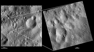
| Опис | Claudia crater, Vesta. An arrow has been added to the image to point out the crater, which is quite small (equal to the width of the arrow). Original caption: HAMO and LAMO images of Claudia crater Download Image › Full Size September 4, 2012 These Dawn framing camera (FC) images of Vesta show Claudia crater at both HAMO (high-altitude mapping orbit) and LAMO (low-altitude mapping orbit) resolutions. The left image is the HAMO image and the right image is the LAMO image. To find Claudia crater use the two relatively large degraded craters that form the figure of eight shape in the bottom left of the LAMO image. On the middle right rim of these craters there is a small crater. About 3 kilometers (1.9 miles) to the bottom right of this crater is Claudia, which is 0.7 kilometers (0.4 miles) in diameter. The LAMO image is approximately three times better spatial resolution than the HAMO image. In images with higher spatial resolutions smaller objects can be better distinguished. Claudia was chosen to anchor the coordinate system for Vesta that is used in the scientific investigations of the Dawn team. Claudia was chosen for this because it is a small crater, which is reasonably easy to find, near Vesta’s equator. These images are located in Vesta’s Oppia quadrangle, just south of Vesta’s equator. NASA’s Dawn spacecraft obtained the left image with its framing camera on Oct. 25, 2011. This image was taken through the camera’s clear filter. The distance to the surface of Vesta is 700 kilometers (435 miles) and the image has a resolution of about 63 meters (207 feet) per pixel. This image was acquired during the HAMO (high-altitude mapping orbit) phase of the mission. NASA’s Dawn spacecraft obtained the right image with its framing camera on April 1, 2012. This image was taken through the camera’s clear filter. The distance to the surface of Vesta is 272 kilometers (169 miles) and the image has a resolution of about 19 meters (62 feet) per pixel. This image was acquired during the LAMO (low-altitude mapping orbit) phase of the mission. |
| Час створення | |
| Джерело | http://dawn.jpl.nasa.gov/multimedia/imageoftheday/image.asp?date=20120904 |
| Автор | NASA/JPL |
Ліцензування
| Цей файл перебуває у суспільному надбанні, оскільки він був створений NASA (Національним управлінням з аеронавтики і дослідження космічного простору). Згідно з політикою NASA стосовно авторського права, «матеріали NASA не захищаються авторським правом, якщо не вказано протилежне». (Див. Template:PD-USGov, сторінку політики NASA стосовно авторського права, або політику використання зображень JPL.) | ||
 | Попередження:
|
Журнал завантажень локального файлу
| Дата/час | Розмір об'єкта | Користувач | Коментар |
|---|---|---|---|
| 2012-09-15 22:30:47 | 2350× 1300× | Kwamikagami | Uploading a public-domain item using [[Wikipedia:File_Upload_Wizard|File Upload Wizard]] |
Історія файлу
Клацніть на дату/час, щоб переглянути, як тоді виглядав файл.
| Дата/час | Мініатюра | Розмір об'єкта | Користувач | Коментар | |
|---|---|---|---|---|---|
| поточний | 20:28, 5 листопада 2016 | | 2350 × 1300 (812 КБ) | Zppix | Transferred from en.wikipedia (MTC!) |
Використання файлу
Такі сторінки використовують цей файл:
Глобальне використання файлу
Цей файл використовують такі інші вікі:
- Використання в en.wikipedia.org
- Використання в en.wikiversity.org
- Використання в es.wikipedia.org
- Використання в et.wikipedia.org
- Використання в mk.wikipedia.org
- Використання в ro.wikipedia.org