
 French
 Deutsch
Файл:First colored image from Curiosity.jpg — Вікіпедія
Повна роздільність (2025 × 1877 пікселів, розмір файлу: 1,16 МБ, MIME-тип: image/jpeg)
| Відомості про цей файл містяться на Вікісховищі — централізованому сховищі вільних файлів мультимедіа для використання у проектах Фонду Вікімедіа. |
Опис файлу
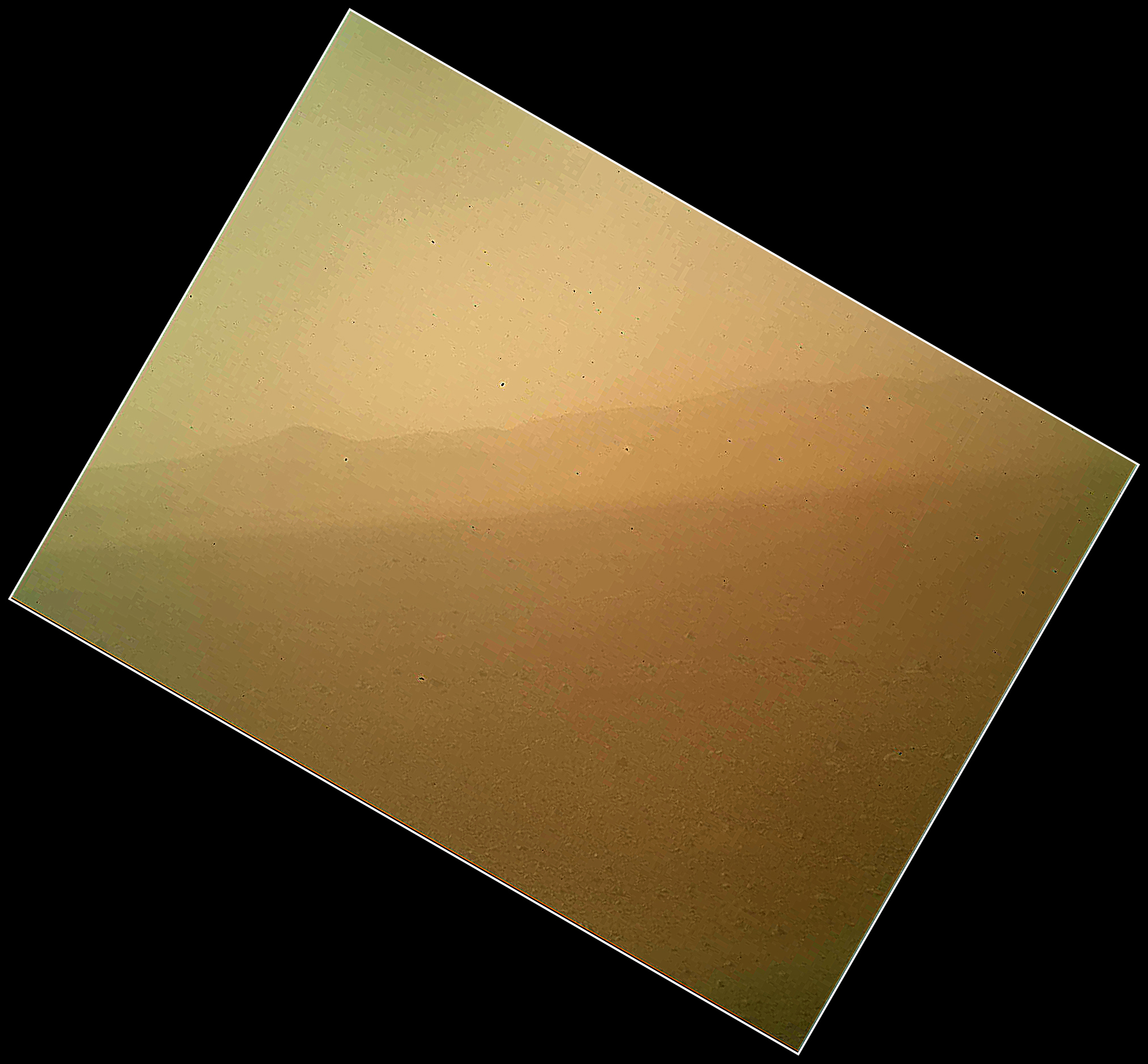
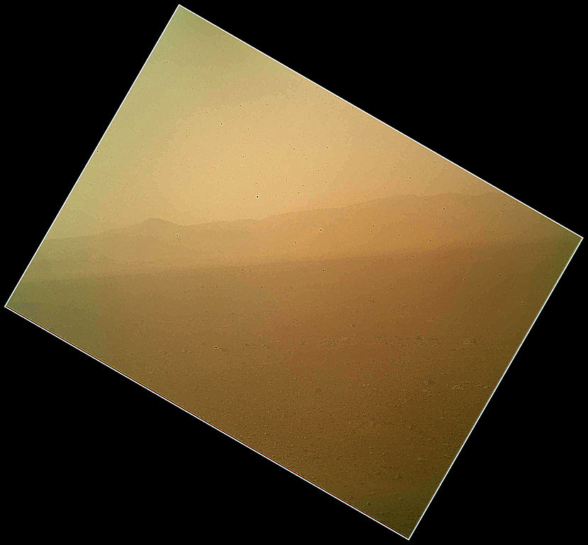
| Опис | English: This view of the landscape to the north of NASA's Mars rover Curiosity was acquired by the Mars Hand Lens Imager (MAHLI) on the afternoon of the first day after landing. (The team calls this day Sol 1, which is the first Martian day of operations; Sol 1 began on Aug. 6, 2012.) In the distance, the image shows the north wall and rim of Gale Crater. The image is murky because the MAHLI's removable dust cover is apparently coated with dust blown onto the camera during the rover's terminal descent. Images taken without the dust cover in place are expected during checkout of the robotic arm in coming weeks. The MAHLI is located on the turret at the end of Curiosity's robotic arm. At the time the MAHLI Sol 1 image was acquired, the robotic arm was in its stowed position. It has been stowed since the rover was packaged for its Nov. 26, 2011, launch. The MAHLI has a transparent dust cover. This image was acquired with the dust cover closed. The cover will not be opened until more than a week after the landing. When the robotic arm, turret, and MAHLI are stowed, the MAHLI is in a position that is rotated 30 degrees relative to the rover deck. The MAHLI image shown here has been rotated to correct for that tilt, so that the sky is "up" and the ground is "down". When the robotic arm, turret, and MAHLI are stowed, the MAHLI is looking out from the front left side of the rover. This is much like the view from the driver's side of cars sold in the USA. The main purpose of Curiosity's MAHLI camera is to acquire close-up, high-resolution views of rocks and soil at the rover's Gale Crater field site. The camera is capable of focusing on any target at distances of about 0.8 inch (2.1 centimeters) to infinity. This means it can, as shown here, also obtain pictures of the Martian landscape. |
| Час створення | |
| Джерело | http://www.nasa.gov/mission_pages/msl/multimedia/PIA15691.html |
| Автор | NASA/JPL-Caltech/Malin Space Science Systems |
Ліцензування
| Цей файл перебуває у суспільному надбанні, оскільки він був створений NASA (Національним управлінням з аеронавтики і дослідження космічного простору). Згідно з політикою NASA стосовно авторського права, «матеріали NASA не захищаються авторським правом, якщо не вказано протилежне». (Див. Template:PD-USGov, сторінку політики NASA стосовно авторського права, або політику використання зображень JPL.) | ||
 | Попередження:
|
Це зображення або відео внесене у каталог Лабораторії реактивного руху Національного управління з аеронавтики і дослідження космічного простору США (NASA)під фото ID: PIA15691. Це не тег авторських прав. Дійсна ліцензія має додаватись до цього тегу. Інші мови:
|
Історія файлу
Клацніть на дату/час, щоб переглянути, як тоді виглядав файл.
| Дата/час | Мініатюра | Розмір об'єкта | Користувач | Коментар | |
|---|---|---|---|---|---|
| поточний | 08:06, 7 серпня 2012 | | 2025 × 1877 (1,16 МБ) | Rehman |
Використання файлу
Такі сторінки використовують цей файл:
Глобальне використання файлу
Цей файл використовують такі інші вікі:
- Використання в bn.wikipedia.org
- Використання в ca.wikipedia.org
- Використання в cs.wikipedia.org
- Використання в cy.wikipedia.org
- Використання в de.wikipedia.org
- Використання в en.wikipedia.org
- Використання в fa.wikipedia.org
- Використання в kk.wikipedia.org
- Використання в ko.wikipedia.org
- Використання в ru.wikipedia.org
- Використання в test.wikipedia.org
- Використання в zh-min-nan.wikipedia.org
- Використання в zh.wikipedia.org