File:Howland island nasa.jpg - 维基百科,自由的百科全书

Howland_island_nasa.jpg(540 × 540像素,文件大小:51 KB,MIME类型:image/jpeg


摘要

描述
Deutsch: NASA-Astronautenbild der Howlandsinsel im Pazifischen Ozean
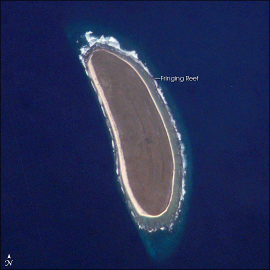
English: NASA astronaut image of Howland Island in the Pacific Ocean


International Space Station InsigniaISS Crew Earth Observations: ISS010-E-9287International Space Station Insignia
Identification
Mission ISS010 (Expedition 10)
Roll E
Frame 9287
Country or Geographic Name HOWLAND ISLAND
Features HOWLAND ISLAND
Center Point Latitude 0.8° N
Center Point Longitude -176.6° E
Camera
Camera Tilt 41°
Camera Focal Length 800 mm
Camera Kodak DCS760C Electronic Still Camera
Film 3060 x 2036 pixel CCD, RGBG array.
Quality
Percentage of Cloud Cover 0-10%
Nadir What is Nadir?
Date 2004-12-03
Time 18:55:48
Nadir Point Latitude 2.7° N
Nadir Point Longitude -174.6° E
Nadir to Photo Center Direction Southwest
Sun Azimuth 115°
Spacecraft Altitude 192 nautical miles (356 km)
Sun Elevation Angle 19°
Orbit Number 2496
Original image caption
Howland Island is a United States possession located in the north Pacific between Australia and the Hawaiian Islands. Prior to 1890, organic nitrate (guano) was mined from the island by both the United States and the British. This tiny island (1.6 km2) is currently part of the U.S. National Wildlife Refuge system, and provides nesting areas and forage for a variety of birds and marine wildlife.

The island is composed of coral fragments and is surrounded by an active fringing reef. White breakers encircling the island indicate the position of the reef. Astronauts aboard the International Space Station photograph numerous reefs around the world as part of a global mapping and monitoring program. High-resolution images such as this one are used to update geographic maps of reefs and islands, assess the health of reef ecosystems, and calculate bathymetry of the surrounding ocean bottom.

日期
来源 http://earthobservatory.nasa.gov/Newsroom/NewImages/Images/ISS010-E-9287_lrg.jpg
作者 NASA
授权
(二次使用本文件)
Conditions of Use of Astronaut Photographs
本图像或视频收录于美国国家航空航天局 (NASA)休斯顿太空中心(Johnson Space Center),其照片编号是: ISS010-E-9287

此标签不表示文件的著作权状态。任何文件在附有此标签的同時还需要一个有效的著作权标签请参阅许可协议说明页面以了解更多信息。
其他语言:

许可协议

Public domain
This file is in the public domain in the United States because it was created by the Image Science & Analysis Laboratory, of the NASA Johnson Space Center. NASA copyright policy states that "NASA material is not protected by copyright unless noted". (NASA media use guidelines or Conditions of Use of Astronaut Photographs). Photo source: ISS010-E-9287.

العربيَّة | Deutsch | English | español | français | italiano | kurdî | македонски | മലയാളം | português | sicilianu | +/−

原始上传日志

All following user names refer to en.wikipedia.

说明

添加一行文字以描述该文件所表现的内容

此文件中描述的项目

描繪內容

文件历史

点击某个日期/时间查看对应时刻的文件。

日期/时间缩⁠略⁠图大小用户备注
当前2006年3月19日 (日) 12:482006年3月19日 (日) 12:48版本的缩略图540 × 540(51 KB)MaksimLa bildo estas kopiita de wikipedia:en. La originala priskribo estas: Howland Island, Pacific Ocean image description [http://earthobservatory.nasa.gov/Newsroom/NewImages/images.php3?img_id=16779 here] larger version [http://earthobservatory.nasa.gov/N

以下页面使用本文件:

全域文件用途

以下其他wiki使用此文件:

查看本文件的更多全域用途

元数据