
 French
 Deutsch
Badanganj
Badanganj | |
|---|---|
Village | |
 Badanganj Location in West Bengal, India  Badanganj Badanganj (India) | |
| Coordinates: 22°54′12″N 87°32′13″E / 22.903199°N 87.536972°E | |
| Country | |
| State | West Bengal |
| District | Hooghly |
| Population (2011) | |
| • Total | 3,865 |
| Languages | |
| • Official | Bengali, English |
| Time zone | UTC+5:30 (IST) |
| PIN | 712122 |
| Telephone/STD code | 03211 |
| Lok Sabha constituency | Arambagh |
| Vidhan Sabha constituency | Goghat |
| Website | hooghly |
Badanganj is a village in the Goghat II CD block in the Arambagh subdivision of Hooghly district in the Indian state of West Bengal.
Geography[edit]


5miles
River
River
River
River
Bayara
M: municipal city/ town, R: rural/ urban centre, H: historical/ religious centre
Owing to space constraints in the small map, the actual locations in a larger map may vary slightly
Area overview[edit]
The Arambagh subdivision, presented in the map alongside, is divided into two physiographic parts – the Dwarakeswar River being the dividing line. The western part is upland and rocky – it is extension of the terrain of neighbouring Bankura district. The eastern part is flat alluvial plain area. The railways, the roads and flood-control measures have had an impact on the area.[1] The area is overwhelmingly rural with 94.77% of the population living in rural areas and 5.23% in urban areas.[2]
Note: The map alongside presents some of the notable locations in the subdivision. All places marked in the map are linked in the larger full screen map.
Location[edit]
Badanganj is located at 22°54′12″N 87°32′13″E / 22.903199°N 87.536972°E
Demographics[edit]
As per the 2011 Census of India, Badanganj had a total population of 3,865 of which 1,957 (51%) were males and 1,908 (49%) were females. Population in the age range 0–6 years was 415. The total number of literate persons in Badanganj was 2,913 (84.43% of the population over 6 years).[3]
Culture[edit]
David J. McCutchion mentions:[4]
- The Damodara temple as a West Bengal nava ratna with ridged turrets, with terracotta façade, built in 1810, measuring 16’ 6" square.
- The Sridhara Laljiu as a double-storied flat roofed, with terracotta designs, built in 1802, measuring 18’ 7" x 17’ 11".
Badanganj picture gallery[edit]
-
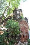 Damodara temple of Barat family built in 1810
 -
 Damodara temple – nava ratna
 -
 Terracotta relief in Damodara temple
 -
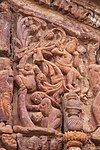 Terracotta relief in Damodara temple
.jpg)
.jpg)
.jpg)
.jpg)
Healthcare[edit]
There is a Primary Health Centre at Badanganj, with 2 beds.[5]
References[edit]
- ^ "District Census Handbook: Hugli, Series-20, Part XIIA" (PDF). Physiography, Page 17-19. Directorate of Census Operations, West Bengal, 2011. Retrieved 25 September 2020.
- ^ "District Statistical Handbook 2014 Hooghly". Table 2.2, 2.4(a). Department of Planning and Statistics, Government of West Bengal. Retrieved 25 September 2020.
- ^ "2011 Census – Primary Census Abstract Data Tables". West Bengal – District-wise. Registrar General and Census Commissioner, India. Retrieved 22 September 2020.
- ^ McCutchion, David J., Late Mediaeval Temples of Bengal, first published 1972, reprinted 2017, pages 51, 67. The Asiatic Society, Kolkata, ISBN 978-93-81574-65-2
- ^ "Health & Family Welfare Department". Health Statistics. Government of West Bengal. Archived from the original on 28 October 2021. Retrieved 22 September 2020.