
 French
 Deutsch
Dubrajpur, Paschim Medinipur
Dubrajpur | |
|---|---|
Village | |
 Dubrajpur Location in West Bengal, India  Dubrajpur Dubrajpur (India) | |
| Coordinates: 22°11′29″N 87°43′29″E / 22.1915°N 87.7246°E | |
| Country | |
| State | West Bengal |
| District | Paschim Medinipur |
| Population (2011) | |
| • Total | 4,578 |
| Languages | |
| • Official | Bengali, English |
| Time zone | UTC+5:30 (IST) |
| PIN | 721144 (Sabang) |
| Telephone/STD code | 03228 |
| Lok Sabha constituency | Ghatal |
| Vidhan Sabha constituency | Sabang |
| Website | paschimmedinipur |
Dubrajpur is a village in the Sabang CD block in the Kharagpur subdivision of the Paschim Medinipur district in the state of West Bengal, India.
Geography[edit]


5miles
CT: census town, R: rural/ urban centre, H: historical/ religious centre
Owing to space constraints in the small map, the actual locations in a larger map may vary slightly
Location[edit]
Dubrajpur is located at 22°11′29″N 87°43′29″E / 22.1915°N 87.7246°E.
Area overview[edit]
Kharagpur subdivision, shown partly in the map alongside, mostly has alluvial soils, except in two CD blocks in the west – Kharagpur I and Keshiary, which mostly have lateritic soils. Around 74% of the total cultivated area is cropped more than once.[1] With a density of population of 787 per km2nearly half of the district's population resides in this subdivision. 14.33% of the population lives in urban areas and 86.67% lives in the rural areas.[2]
Note: The map alongside presents some of the notable locations in the subdivision. All places marked in the map are linked in the larger full screen map.
Demographics[edit]
According to the 2011 Census of India, Dubrajpur had a total population of 4,578, of which 2,372 (52%) were males and 2,206 (48%) were females. There were 589 persons in the age range of 0–6 years. The total number of literate persons in Dubrajpur was 3,420 (85.74% of the population over 6 years).[3]
Culture[edit]
David J. McCutchion mentions the early 19th century Lakshmi Janardana temple as a rich terracotta West Bengal Nava-ratna with ridged turrets measuring 21’ 2" square.[4]
Dubrajpur picture gallery[edit]
-
 Lakshmi Janardana temple
 -
 Lakshmi Janardana temple
 -
 Terracotta panels
 -
 Terracotta panels
 -
 Terracotta panels
 -
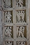 Cavings on wooden door


References[edit]
- ^ "District Human Development Report Paschim Medinipur, 2011". page 27-28. Department of Planning and Statistics, Government of West Bengal. Retrieved 10 September 2020.
- ^ "District Statistical Handbook Paschim Medinipur, 2013". Table 2.2, 2.4 (a). Department of Planning and Statistics. Retrieved 10 September 2020.
- ^ "CD block Wise Primary Census Abstract Data(PCA)". West Bengal – District-wise CD blocks. Registrar General and Census, India. Retrieved 19 August 2020.
- ^ McCutchion, David J., Late Mediaeval Temples of Bengal, first published 1972, reprinted 2017, page 51. The Asiatic Society, Kolkata, ISBN 978-93-81574-65-2
External links[edit]

This article about a location in the Paschim Medinipur district of West Bengal is a stub. You can help Wikipedia by expanding it. |